
If Navi Mumbai is to continue to show Indian cities the way to develop and be an inspiration to further endeavours in planning, it must showcase a way to include slums and the needs they represent even in planned cities. Navi Mumbai must chart its own plan, its own future, just like it did 50 years ago. Most importantly, its elected body must be given the power to do so.
[/vc_column_text][/vc_column][/vc_row] This complexity has had severe repercussions on slums that lie on these ambiguous land boundaries. Most households in slums exist on insecure tenure and lack formal land documentation, in spite of having existed for decades. Land contestations interfere with people’s efforts to gain any form of formal documentation from authorities. This land division has furthered what Shirish Patel, one the chief architects of Navi Mumbai, terms as the ‘balkanisation of planning’ where no single authority is able to holistically plan for a city. Perhaps in such situations, in the guise of ambiguity, it becomes convenient for the authorities to side-line issue of the urban poor.Ways forward
As the future for India’s largest planned city is being decided for the next two decades, it needs to acknowledge its present. The development plan 2018–2038 is about people who have come to inhabit the city. There must be a participative, inclusive process that acknowledges the contribution of thousands of workers who have built and continue to sustain it. It must account for their habitats by counting the numbers of slums accurately, reserve land occupied by existing slums under the ‘Slum improvement zone’ reservation or under a ‘Public Housing’ reservation where there must be options for self-development and upgradation, beyond the Slum Rehabilitation Scheme that has not seen much success at creating adequate habitats. It must include options for rental housing for migrant families.
If Navi Mumbai is to continue to show Indian cities the way to develop and be an inspiration to further endeavours in planning, it must showcase a way to include slums and the needs they represent even in planned cities. Navi Mumbai must chart its own plan, its own future, just like it did 50 years ago. Most importantly, its elected body must be given the power to do so.
[/vc_column_text][/vc_column][/vc_row]
Ambiguous governance boundaries and land contestation
Powers as planning authority were delegated to NMMC partly in 1994 and 2008 when CIDCO handed over select plots to the NMMC. In 2017 CIDCO was appointed as Special Planning Authority (SPA) for select areas. Similarly, the MIDC is the SPA for the industrial areas. This shift of authorities has been gradual and coupled with land contestation, with CIDCO, MIDC and NMMC in the powerplay.
In the context of the draft DP, the proposed plan thus only considers planning for 7 nodes in the NMMC boundary, while the rest of the land parcels are viewed as separate domains. This not only excludes a large population residing in these areas but it also exacerbates the anxieties for their future. As a result, the urban local body (NMMC) which is deemed to develop a cohesive DP for the region, has excluded large parcels of land resulting in a disjunct planning proposal.
An analysis of planning areas shows that MIDC currently accounts for 17% (approx 25 sq km) of Navi Mumbai while CIDCO accounts for large swathes measuring 10 sq km and many smaller plots within nodes. This percentage is high — the report mentions 975 plots that are yet to be handed over to NMMC and that 90% of land in Navi Mumbai is owned by CIDCO. During the preparation of the current DP that began in 2017, the Urban Development Department and CIDCO have raised concerns regarding the plan. As per objection raised by CIDCO, the Government of Maharashtra issued directions to NMMC in 2021 not to propose reservation on any plot owned by CIDCO measuring more than 500 sq.m.
This complexity has had severe repercussions on slums that lie on these ambiguous land boundaries. Most households in slums exist on insecure tenure and lack formal land documentation, in spite of having existed for decades. Land contestations interfere with people’s efforts to gain any form of formal documentation from authorities. This land division has furthered what Shirish Patel, one the chief architects of Navi Mumbai, terms as the ‘balkanisation of planning’ where no single authority is able to holistically plan for a city. Perhaps in such situations, in the guise of ambiguity, it becomes convenient for the authorities to side-line issue of the urban poor.
Ways forward
As the future for India’s largest planned city is being decided for the next two decades, it needs to acknowledge its present. The development plan 2018–2038 is about people who have come to inhabit the city. There must be a participative, inclusive process that acknowledges the contribution of thousands of workers who have built and continue to sustain it. It must account for their habitats by counting the numbers of slums accurately, reserve land occupied by existing slums under the ‘Slum improvement zone’ reservation or under a ‘Public Housing’ reservation where there must be options for self-development and upgradation, beyond the Slum Rehabilitation Scheme that has not seen much success at creating adequate habitats. It must include options for rental housing for migrant families.
If Navi Mumbai is to continue to show Indian cities the way to develop and be an inspiration to further endeavours in planning, it must showcase a way to include slums and the needs they represent even in planned cities. Navi Mumbai must chart its own plan, its own future, just like it did 50 years ago. Most importantly, its elected body must be given the power to do so.
[/vc_column_text][/vc_column][/vc_row]
Through the UDCPR regulations for slums, one thing clear is that slum redevelopment and resultant slum TDR to be earned in the process, is a state wide tailor-made solution for existing slums that meet the cut-off date.
Ambiguous governance boundaries and land contestation
Powers as planning authority were delegated to NMMC partly in 1994 and 2008 when CIDCO handed over select plots to the NMMC. In 2017 CIDCO was appointed as Special Planning Authority (SPA) for select areas. Similarly, the MIDC is the SPA for the industrial areas. This shift of authorities has been gradual and coupled with land contestation, with CIDCO, MIDC and NMMC in the powerplay.
In the context of the draft DP, the proposed plan thus only considers planning for 7 nodes in the NMMC boundary, while the rest of the land parcels are viewed as separate domains. This not only excludes a large population residing in these areas but it also exacerbates the anxieties for their future. As a result, the urban local body (NMMC) which is deemed to develop a cohesive DP for the region, has excluded large parcels of land resulting in a disjunct planning proposal.
An analysis of planning areas shows that MIDC currently accounts for 17% (approx 25 sq km) of Navi Mumbai while CIDCO accounts for large swathes measuring 10 sq km and many smaller plots within nodes. This percentage is high — the report mentions 975 plots that are yet to be handed over to NMMC and that 90% of land in Navi Mumbai is owned by CIDCO. During the preparation of the current DP that began in 2017, the Urban Development Department and CIDCO have raised concerns regarding the plan. As per objection raised by CIDCO, the Government of Maharashtra issued directions to NMMC in 2021 not to propose reservation on any plot owned by CIDCO measuring more than 500 sq.m.
This complexity has had severe repercussions on slums that lie on these ambiguous land boundaries. Most households in slums exist on insecure tenure and lack formal land documentation, in spite of having existed for decades. Land contestations interfere with people’s efforts to gain any form of formal documentation from authorities. This land division has furthered what Shirish Patel, one the chief architects of Navi Mumbai, terms as the ‘balkanisation of planning’ where no single authority is able to holistically plan for a city. Perhaps in such situations, in the guise of ambiguity, it becomes convenient for the authorities to side-line issue of the urban poor.
Ways forward
As the future for India’s largest planned city is being decided for the next two decades, it needs to acknowledge its present. The development plan 2018–2038 is about people who have come to inhabit the city. There must be a participative, inclusive process that acknowledges the contribution of thousands of workers who have built and continue to sustain it. It must account for their habitats by counting the numbers of slums accurately, reserve land occupied by existing slums under the ‘Slum improvement zone’ reservation or under a ‘Public Housing’ reservation where there must be options for self-development and upgradation, beyond the Slum Rehabilitation Scheme that has not seen much success at creating adequate habitats. It must include options for rental housing for migrant families.
If Navi Mumbai is to continue to show Indian cities the way to develop and be an inspiration to further endeavours in planning, it must showcase a way to include slums and the needs they represent even in planned cities. Navi Mumbai must chart its own plan, its own future, just like it did 50 years ago. Most importantly, its elected body must be given the power to do so.
[/vc_column_text][/vc_column][/vc_row]
The CIDCO DCRs for Navi Mumbai (1975), amended in 2016 for CIDCO areas, applicable to the CIDCO planning areas and plots, do not outline any clear provision for slum upgradation or rehabilitation. The MIDC DCRs (revised 2009) applicable to the MIDC planning areas, includes basic provisions on formal housing for industrial workers. Both DCRs however refer to ‘Group Housing Scheme’ and ‘Plotted Development Scheme’. These appear that they could allow for a body like the Slum Rehabilitation Authority, however clear rules for slums have not been spelt out. A 2020 GR however, does include SRS on Navi Mumbai and CIDCO land.
Through the UDCPR regulations for slums, one thing clear is that slum redevelopment and resultant slum TDR to be earned in the process, is a state wide tailor-made solution for existing slums that meet the cut-off date.
Ambiguous governance boundaries and land contestation
Powers as planning authority were delegated to NMMC partly in 1994 and 2008 when CIDCO handed over select plots to the NMMC. In 2017 CIDCO was appointed as Special Planning Authority (SPA) for select areas. Similarly, the MIDC is the SPA for the industrial areas. This shift of authorities has been gradual and coupled with land contestation, with CIDCO, MIDC and NMMC in the powerplay.
In the context of the draft DP, the proposed plan thus only considers planning for 7 nodes in the NMMC boundary, while the rest of the land parcels are viewed as separate domains. This not only excludes a large population residing in these areas but it also exacerbates the anxieties for their future. As a result, the urban local body (NMMC) which is deemed to develop a cohesive DP for the region, has excluded large parcels of land resulting in a disjunct planning proposal.
An analysis of planning areas shows that MIDC currently accounts for 17% (approx 25 sq km) of Navi Mumbai while CIDCO accounts for large swathes measuring 10 sq km and many smaller plots within nodes. This percentage is high — the report mentions 975 plots that are yet to be handed over to NMMC and that 90% of land in Navi Mumbai is owned by CIDCO. During the preparation of the current DP that began in 2017, the Urban Development Department and CIDCO have raised concerns regarding the plan. As per objection raised by CIDCO, the Government of Maharashtra issued directions to NMMC in 2021 not to propose reservation on any plot owned by CIDCO measuring more than 500 sq.m.
This complexity has had severe repercussions on slums that lie on these ambiguous land boundaries. Most households in slums exist on insecure tenure and lack formal land documentation, in spite of having existed for decades. Land contestations interfere with people’s efforts to gain any form of formal documentation from authorities. This land division has furthered what Shirish Patel, one the chief architects of Navi Mumbai, terms as the ‘balkanisation of planning’ where no single authority is able to holistically plan for a city. Perhaps in such situations, in the guise of ambiguity, it becomes convenient for the authorities to side-line issue of the urban poor.
Ways forward
As the future for India’s largest planned city is being decided for the next two decades, it needs to acknowledge its present. The development plan 2018–2038 is about people who have come to inhabit the city. There must be a participative, inclusive process that acknowledges the contribution of thousands of workers who have built and continue to sustain it. It must account for their habitats by counting the numbers of slums accurately, reserve land occupied by existing slums under the ‘Slum improvement zone’ reservation or under a ‘Public Housing’ reservation where there must be options for self-development and upgradation, beyond the Slum Rehabilitation Scheme that has not seen much success at creating adequate habitats. It must include options for rental housing for migrant families.
If Navi Mumbai is to continue to show Indian cities the way to develop and be an inspiration to further endeavours in planning, it must showcase a way to include slums and the needs they represent even in planned cities. Navi Mumbai must chart its own plan, its own future, just like it did 50 years ago. Most importantly, its elected body must be given the power to do so.
[/vc_column_text][/vc_column][/vc_row]
The Maharashtra Unified Development Control Promotion Regulation applicable to the NMMC planning area includes various forms of seemingly progressive housing options such as Inclusive Housing, Social Housing (Rental housing), Affordable Housing for EWS/LIG, Pradhan Mantri Awas Yojana for EWS/LIG. It also details the ‘Slum Improvement Zone’ as being included within ‘Residential R-1’ land use reservation and notes that it shall be developed as per the Slum Rehabilitation Scheme of the Maharashtra Slum Act (Ibid.).
The CIDCO DCRs for Navi Mumbai (1975), amended in 2016 for CIDCO areas, applicable to the CIDCO planning areas and plots, do not outline any clear provision for slum upgradation or rehabilitation. The MIDC DCRs (revised 2009) applicable to the MIDC planning areas, includes basic provisions on formal housing for industrial workers. Both DCRs however refer to ‘Group Housing Scheme’ and ‘Plotted Development Scheme’. These appear that they could allow for a body like the Slum Rehabilitation Authority, however clear rules for slums have not been spelt out. A 2020 GR however, does include SRS on Navi Mumbai and CIDCO land.
Through the UDCPR regulations for slums, one thing clear is that slum redevelopment and resultant slum TDR to be earned in the process, is a state wide tailor-made solution for existing slums that meet the cut-off date.
Ambiguous governance boundaries and land contestation
Powers as planning authority were delegated to NMMC partly in 1994 and 2008 when CIDCO handed over select plots to the NMMC. In 2017 CIDCO was appointed as Special Planning Authority (SPA) for select areas. Similarly, the MIDC is the SPA for the industrial areas. This shift of authorities has been gradual and coupled with land contestation, with CIDCO, MIDC and NMMC in the powerplay.
In the context of the draft DP, the proposed plan thus only considers planning for 7 nodes in the NMMC boundary, while the rest of the land parcels are viewed as separate domains. This not only excludes a large population residing in these areas but it also exacerbates the anxieties for their future. As a result, the urban local body (NMMC) which is deemed to develop a cohesive DP for the region, has excluded large parcels of land resulting in a disjunct planning proposal.
An analysis of planning areas shows that MIDC currently accounts for 17% (approx 25 sq km) of Navi Mumbai while CIDCO accounts for large swathes measuring 10 sq km and many smaller plots within nodes. This percentage is high — the report mentions 975 plots that are yet to be handed over to NMMC and that 90% of land in Navi Mumbai is owned by CIDCO. During the preparation of the current DP that began in 2017, the Urban Development Department and CIDCO have raised concerns regarding the plan. As per objection raised by CIDCO, the Government of Maharashtra issued directions to NMMC in 2021 not to propose reservation on any plot owned by CIDCO measuring more than 500 sq.m.
This complexity has had severe repercussions on slums that lie on these ambiguous land boundaries. Most households in slums exist on insecure tenure and lack formal land documentation, in spite of having existed for decades. Land contestations interfere with people’s efforts to gain any form of formal documentation from authorities. This land division has furthered what Shirish Patel, one the chief architects of Navi Mumbai, terms as the ‘balkanisation of planning’ where no single authority is able to holistically plan for a city. Perhaps in such situations, in the guise of ambiguity, it becomes convenient for the authorities to side-line issue of the urban poor.
Ways forward
As the future for India’s largest planned city is being decided for the next two decades, it needs to acknowledge its present. The development plan 2018–2038 is about people who have come to inhabit the city. There must be a participative, inclusive process that acknowledges the contribution of thousands of workers who have built and continue to sustain it. It must account for their habitats by counting the numbers of slums accurately, reserve land occupied by existing slums under the ‘Slum improvement zone’ reservation or under a ‘Public Housing’ reservation where there must be options for self-development and upgradation, beyond the Slum Rehabilitation Scheme that has not seen much success at creating adequate habitats. It must include options for rental housing for migrant families.
If Navi Mumbai is to continue to show Indian cities the way to develop and be an inspiration to further endeavours in planning, it must showcase a way to include slums and the needs they represent even in planned cities. Navi Mumbai must chart its own plan, its own future, just like it did 50 years ago. Most importantly, its elected body must be given the power to do so.
[/vc_column_text][/vc_column][/vc_row]
What the Development Control Regulations (DCRs) state
The Maharashtra Unified Development Control Promotion Regulation applicable to the NMMC planning area includes various forms of seemingly progressive housing options such as Inclusive Housing, Social Housing (Rental housing), Affordable Housing for EWS/LIG, Pradhan Mantri Awas Yojana for EWS/LIG. It also details the ‘Slum Improvement Zone’ as being included within ‘Residential R-1’ land use reservation and notes that it shall be developed as per the Slum Rehabilitation Scheme of the Maharashtra Slum Act (Ibid.).
The CIDCO DCRs for Navi Mumbai (1975), amended in 2016 for CIDCO areas, applicable to the CIDCO planning areas and plots, do not outline any clear provision for slum upgradation or rehabilitation. The MIDC DCRs (revised 2009) applicable to the MIDC planning areas, includes basic provisions on formal housing for industrial workers. Both DCRs however refer to ‘Group Housing Scheme’ and ‘Plotted Development Scheme’. These appear that they could allow for a body like the Slum Rehabilitation Authority, however clear rules for slums have not been spelt out. A 2020 GR however, does include SRS on Navi Mumbai and CIDCO land.
Through the UDCPR regulations for slums, one thing clear is that slum redevelopment and resultant slum TDR to be earned in the process, is a state wide tailor-made solution for existing slums that meet the cut-off date.
Ambiguous governance boundaries and land contestation
Powers as planning authority were delegated to NMMC partly in 1994 and 2008 when CIDCO handed over select plots to the NMMC. In 2017 CIDCO was appointed as Special Planning Authority (SPA) for select areas. Similarly, the MIDC is the SPA for the industrial areas. This shift of authorities has been gradual and coupled with land contestation, with CIDCO, MIDC and NMMC in the powerplay.
In the context of the draft DP, the proposed plan thus only considers planning for 7 nodes in the NMMC boundary, while the rest of the land parcels are viewed as separate domains. This not only excludes a large population residing in these areas but it also exacerbates the anxieties for their future. As a result, the urban local body (NMMC) which is deemed to develop a cohesive DP for the region, has excluded large parcels of land resulting in a disjunct planning proposal.
An analysis of planning areas shows that MIDC currently accounts for 17% (approx 25 sq km) of Navi Mumbai while CIDCO accounts for large swathes measuring 10 sq km and many smaller plots within nodes. This percentage is high — the report mentions 975 plots that are yet to be handed over to NMMC and that 90% of land in Navi Mumbai is owned by CIDCO. During the preparation of the current DP that began in 2017, the Urban Development Department and CIDCO have raised concerns regarding the plan. As per objection raised by CIDCO, the Government of Maharashtra issued directions to NMMC in 2021 not to propose reservation on any plot owned by CIDCO measuring more than 500 sq.m.
This complexity has had severe repercussions on slums that lie on these ambiguous land boundaries. Most households in slums exist on insecure tenure and lack formal land documentation, in spite of having existed for decades. Land contestations interfere with people’s efforts to gain any form of formal documentation from authorities. This land division has furthered what Shirish Patel, one the chief architects of Navi Mumbai, terms as the ‘balkanisation of planning’ where no single authority is able to holistically plan for a city. Perhaps in such situations, in the guise of ambiguity, it becomes convenient for the authorities to side-line issue of the urban poor.
Ways forward
As the future for India’s largest planned city is being decided for the next two decades, it needs to acknowledge its present. The development plan 2018–2038 is about people who have come to inhabit the city. There must be a participative, inclusive process that acknowledges the contribution of thousands of workers who have built and continue to sustain it. It must account for their habitats by counting the numbers of slums accurately, reserve land occupied by existing slums under the ‘Slum improvement zone’ reservation or under a ‘Public Housing’ reservation where there must be options for self-development and upgradation, beyond the Slum Rehabilitation Scheme that has not seen much success at creating adequate habitats. It must include options for rental housing for migrant families.
If Navi Mumbai is to continue to show Indian cities the way to develop and be an inspiration to further endeavours in planning, it must showcase a way to include slums and the needs they represent even in planned cities. Navi Mumbai must chart its own plan, its own future, just like it did 50 years ago. Most importantly, its elected body must be given the power to do so.
[/vc_column_text][/vc_column][/vc_row]
When reservations are superimposed on existing slums, they fail to acknowledge their existence. When coupled with the multiple planning authorities that plan for these areas, they point to an unknown future and in many cases, potential evictions.
What the Development Control Regulations (DCRs) state
The Maharashtra Unified Development Control Promotion Regulation applicable to the NMMC planning area includes various forms of seemingly progressive housing options such as Inclusive Housing, Social Housing (Rental housing), Affordable Housing for EWS/LIG, Pradhan Mantri Awas Yojana for EWS/LIG. It also details the ‘Slum Improvement Zone’ as being included within ‘Residential R-1’ land use reservation and notes that it shall be developed as per the Slum Rehabilitation Scheme of the Maharashtra Slum Act (Ibid.).
The CIDCO DCRs for Navi Mumbai (1975), amended in 2016 for CIDCO areas, applicable to the CIDCO planning areas and plots, do not outline any clear provision for slum upgradation or rehabilitation. The MIDC DCRs (revised 2009) applicable to the MIDC planning areas, includes basic provisions on formal housing for industrial workers. Both DCRs however refer to ‘Group Housing Scheme’ and ‘Plotted Development Scheme’. These appear that they could allow for a body like the Slum Rehabilitation Authority, however clear rules for slums have not been spelt out. A 2020 GR however, does include SRS on Navi Mumbai and CIDCO land.
Through the UDCPR regulations for slums, one thing clear is that slum redevelopment and resultant slum TDR to be earned in the process, is a state wide tailor-made solution for existing slums that meet the cut-off date.
Ambiguous governance boundaries and land contestation
Powers as planning authority were delegated to NMMC partly in 1994 and 2008 when CIDCO handed over select plots to the NMMC. In 2017 CIDCO was appointed as Special Planning Authority (SPA) for select areas. Similarly, the MIDC is the SPA for the industrial areas. This shift of authorities has been gradual and coupled with land contestation, with CIDCO, MIDC and NMMC in the powerplay.
In the context of the draft DP, the proposed plan thus only considers planning for 7 nodes in the NMMC boundary, while the rest of the land parcels are viewed as separate domains. This not only excludes a large population residing in these areas but it also exacerbates the anxieties for their future. As a result, the urban local body (NMMC) which is deemed to develop a cohesive DP for the region, has excluded large parcels of land resulting in a disjunct planning proposal.
An analysis of planning areas shows that MIDC currently accounts for 17% (approx 25 sq km) of Navi Mumbai while CIDCO accounts for large swathes measuring 10 sq km and many smaller plots within nodes. This percentage is high — the report mentions 975 plots that are yet to be handed over to NMMC and that 90% of land in Navi Mumbai is owned by CIDCO. During the preparation of the current DP that began in 2017, the Urban Development Department and CIDCO have raised concerns regarding the plan. As per objection raised by CIDCO, the Government of Maharashtra issued directions to NMMC in 2021 not to propose reservation on any plot owned by CIDCO measuring more than 500 sq.m.
This complexity has had severe repercussions on slums that lie on these ambiguous land boundaries. Most households in slums exist on insecure tenure and lack formal land documentation, in spite of having existed for decades. Land contestations interfere with people’s efforts to gain any form of formal documentation from authorities. This land division has furthered what Shirish Patel, one the chief architects of Navi Mumbai, terms as the ‘balkanisation of planning’ where no single authority is able to holistically plan for a city. Perhaps in such situations, in the guise of ambiguity, it becomes convenient for the authorities to side-line issue of the urban poor.
Ways forward
As the future for India’s largest planned city is being decided for the next two decades, it needs to acknowledge its present. The development plan 2018–2038 is about people who have come to inhabit the city. There must be a participative, inclusive process that acknowledges the contribution of thousands of workers who have built and continue to sustain it. It must account for their habitats by counting the numbers of slums accurately, reserve land occupied by existing slums under the ‘Slum improvement zone’ reservation or under a ‘Public Housing’ reservation where there must be options for self-development and upgradation, beyond the Slum Rehabilitation Scheme that has not seen much success at creating adequate habitats. It must include options for rental housing for migrant families.
If Navi Mumbai is to continue to show Indian cities the way to develop and be an inspiration to further endeavours in planning, it must showcase a way to include slums and the needs they represent even in planned cities. Navi Mumbai must chart its own plan, its own future, just like it did 50 years ago. Most importantly, its elected body must be given the power to do so.
[/vc_column_text][/vc_column][/vc_row]
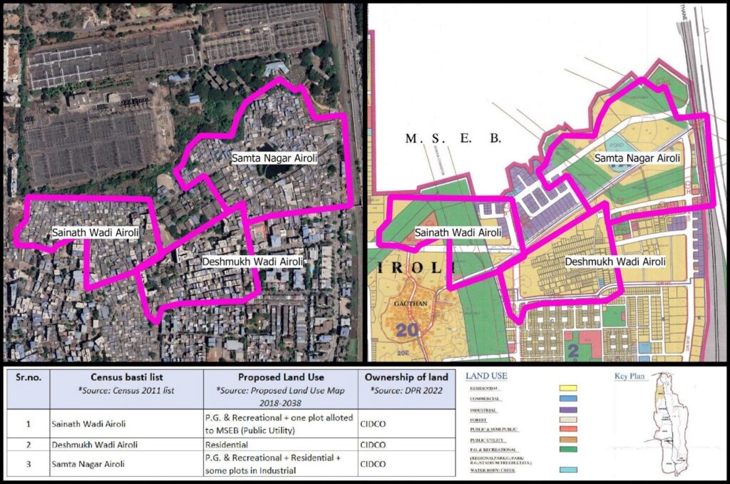
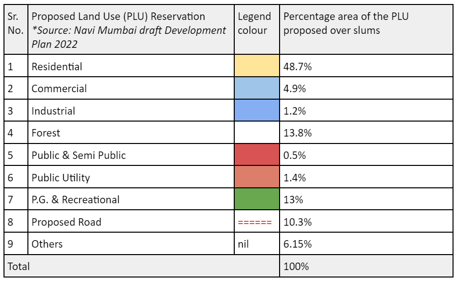
An analysis of Proposed Land Use reservations on areas occupied by slums reflects the invisibilisation of slums — 48.7% area of slums are reserved as residential, 13.8% area of slums are reserved as forest, 13% area of slums are reserved as PlayGround and Recreation, 10.3% area is reserved as proposed roads. Further details are in Table 1. The ‘Slum Improvement Zone’, has not been included as a land use category in the proposed land use maps. The broad residential reservation in the proposed land use maps does not delineate this as a sub category.
When reservations are superimposed on existing slums, they fail to acknowledge their existence. When coupled with the multiple planning authorities that plan for these areas, they point to an unknown future and in many cases, potential evictions.
What the Development Control Regulations (DCRs) state
The Maharashtra Unified Development Control Promotion Regulation applicable to the NMMC planning area includes various forms of seemingly progressive housing options such as Inclusive Housing, Social Housing (Rental housing), Affordable Housing for EWS/LIG, Pradhan Mantri Awas Yojana for EWS/LIG. It also details the ‘Slum Improvement Zone’ as being included within ‘Residential R-1’ land use reservation and notes that it shall be developed as per the Slum Rehabilitation Scheme of the Maharashtra Slum Act (Ibid.).
The CIDCO DCRs for Navi Mumbai (1975), amended in 2016 for CIDCO areas, applicable to the CIDCO planning areas and plots, do not outline any clear provision for slum upgradation or rehabilitation. The MIDC DCRs (revised 2009) applicable to the MIDC planning areas, includes basic provisions on formal housing for industrial workers. Both DCRs however refer to ‘Group Housing Scheme’ and ‘Plotted Development Scheme’. These appear that they could allow for a body like the Slum Rehabilitation Authority, however clear rules for slums have not been spelt out. A 2020 GR however, does include SRS on Navi Mumbai and CIDCO land.
Through the UDCPR regulations for slums, one thing clear is that slum redevelopment and resultant slum TDR to be earned in the process, is a state wide tailor-made solution for existing slums that meet the cut-off date.
Ambiguous governance boundaries and land contestation
Powers as planning authority were delegated to NMMC partly in 1994 and 2008 when CIDCO handed over select plots to the NMMC. In 2017 CIDCO was appointed as Special Planning Authority (SPA) for select areas. Similarly, the MIDC is the SPA for the industrial areas. This shift of authorities has been gradual and coupled with land contestation, with CIDCO, MIDC and NMMC in the powerplay.
In the context of the draft DP, the proposed plan thus only considers planning for 7 nodes in the NMMC boundary, while the rest of the land parcels are viewed as separate domains. This not only excludes a large population residing in these areas but it also exacerbates the anxieties for their future. As a result, the urban local body (NMMC) which is deemed to develop a cohesive DP for the region, has excluded large parcels of land resulting in a disjunct planning proposal.
An analysis of planning areas shows that MIDC currently accounts for 17% (approx 25 sq km) of Navi Mumbai while CIDCO accounts for large swathes measuring 10 sq km and many smaller plots within nodes. This percentage is high — the report mentions 975 plots that are yet to be handed over to NMMC and that 90% of land in Navi Mumbai is owned by CIDCO. During the preparation of the current DP that began in 2017, the Urban Development Department and CIDCO have raised concerns regarding the plan. As per objection raised by CIDCO, the Government of Maharashtra issued directions to NMMC in 2021 not to propose reservation on any plot owned by CIDCO measuring more than 500 sq.m.
This complexity has had severe repercussions on slums that lie on these ambiguous land boundaries. Most households in slums exist on insecure tenure and lack formal land documentation, in spite of having existed for decades. Land contestations interfere with people’s efforts to gain any form of formal documentation from authorities. This land division has furthered what Shirish Patel, one the chief architects of Navi Mumbai, terms as the ‘balkanisation of planning’ where no single authority is able to holistically plan for a city. Perhaps in such situations, in the guise of ambiguity, it becomes convenient for the authorities to side-line issue of the urban poor.
Ways forward
As the future for India’s largest planned city is being decided for the next two decades, it needs to acknowledge its present. The development plan 2018–2038 is about people who have come to inhabit the city. There must be a participative, inclusive process that acknowledges the contribution of thousands of workers who have built and continue to sustain it. It must account for their habitats by counting the numbers of slums accurately, reserve land occupied by existing slums under the ‘Slum improvement zone’ reservation or under a ‘Public Housing’ reservation where there must be options for self-development and upgradation, beyond the Slum Rehabilitation Scheme that has not seen much success at creating adequate habitats. It must include options for rental housing for migrant families.
If Navi Mumbai is to continue to show Indian cities the way to develop and be an inspiration to further endeavours in planning, it must showcase a way to include slums and the needs they represent even in planned cities. Navi Mumbai must chart its own plan, its own future, just like it did 50 years ago. Most importantly, its elected body must be given the power to do so.
[/vc_column_text][/vc_column][/vc_row]
While the report has relied on the 2011 Census list that lists 47 slums within Navi Mumbai; of the 47 only 11 slums (23%) are within the jurisdiction of the NMMC planning boundary. Of bigger concern is that only 4 slums in the Vashi-Turbhe area (Turbhe Stores, Indira Nagar (part), Ganpati Pada, Warli Pada, Hanuman Nagar) are on land belonging to the state government. 36 slums are on land belonging to MIDC and CIDCO. Of the 76 slums identified in the 2022 YUVA-GHSS survey, only 28 lie in the NMMC planning area. Given that MIDC and CIDCO are Special Planning Authorities, the future of the majority of slums in the city remains in limbo.
An analysis of Proposed Land Use reservations on areas occupied by slums reflects the invisibilisation of slums — 48.7% area of slums are reserved as residential, 13.8% area of slums are reserved as forest, 13% area of slums are reserved as PlayGround and Recreation, 10.3% area is reserved as proposed roads. Further details are in Table 1. The ‘Slum Improvement Zone’, has not been included as a land use category in the proposed land use maps. The broad residential reservation in the proposed land use maps does not delineate this as a sub category.
When reservations are superimposed on existing slums, they fail to acknowledge their existence. When coupled with the multiple planning authorities that plan for these areas, they point to an unknown future and in many cases, potential evictions.
What the Development Control Regulations (DCRs) state
The Maharashtra Unified Development Control Promotion Regulation applicable to the NMMC planning area includes various forms of seemingly progressive housing options such as Inclusive Housing, Social Housing (Rental housing), Affordable Housing for EWS/LIG, Pradhan Mantri Awas Yojana for EWS/LIG. It also details the ‘Slum Improvement Zone’ as being included within ‘Residential R-1’ land use reservation and notes that it shall be developed as per the Slum Rehabilitation Scheme of the Maharashtra Slum Act (Ibid.).
The CIDCO DCRs for Navi Mumbai (1975), amended in 2016 for CIDCO areas, applicable to the CIDCO planning areas and plots, do not outline any clear provision for slum upgradation or rehabilitation. The MIDC DCRs (revised 2009) applicable to the MIDC planning areas, includes basic provisions on formal housing for industrial workers. Both DCRs however refer to ‘Group Housing Scheme’ and ‘Plotted Development Scheme’. These appear that they could allow for a body like the Slum Rehabilitation Authority, however clear rules for slums have not been spelt out. A 2020 GR however, does include SRS on Navi Mumbai and CIDCO land.
Through the UDCPR regulations for slums, one thing clear is that slum redevelopment and resultant slum TDR to be earned in the process, is a state wide tailor-made solution for existing slums that meet the cut-off date.
Ambiguous governance boundaries and land contestation
Powers as planning authority were delegated to NMMC partly in 1994 and 2008 when CIDCO handed over select plots to the NMMC. In 2017 CIDCO was appointed as Special Planning Authority (SPA) for select areas. Similarly, the MIDC is the SPA for the industrial areas. This shift of authorities has been gradual and coupled with land contestation, with CIDCO, MIDC and NMMC in the powerplay.
In the context of the draft DP, the proposed plan thus only considers planning for 7 nodes in the NMMC boundary, while the rest of the land parcels are viewed as separate domains. This not only excludes a large population residing in these areas but it also exacerbates the anxieties for their future. As a result, the urban local body (NMMC) which is deemed to develop a cohesive DP for the region, has excluded large parcels of land resulting in a disjunct planning proposal.
An analysis of planning areas shows that MIDC currently accounts for 17% (approx 25 sq km) of Navi Mumbai while CIDCO accounts for large swathes measuring 10 sq km and many smaller plots within nodes. This percentage is high — the report mentions 975 plots that are yet to be handed over to NMMC and that 90% of land in Navi Mumbai is owned by CIDCO. During the preparation of the current DP that began in 2017, the Urban Development Department and CIDCO have raised concerns regarding the plan. As per objection raised by CIDCO, the Government of Maharashtra issued directions to NMMC in 2021 not to propose reservation on any plot owned by CIDCO measuring more than 500 sq.m.
This complexity has had severe repercussions on slums that lie on these ambiguous land boundaries. Most households in slums exist on insecure tenure and lack formal land documentation, in spite of having existed for decades. Land contestations interfere with people’s efforts to gain any form of formal documentation from authorities. This land division has furthered what Shirish Patel, one the chief architects of Navi Mumbai, terms as the ‘balkanisation of planning’ where no single authority is able to holistically plan for a city. Perhaps in such situations, in the guise of ambiguity, it becomes convenient for the authorities to side-line issue of the urban poor.
Ways forward
As the future for India’s largest planned city is being decided for the next two decades, it needs to acknowledge its present. The development plan 2018–2038 is about people who have come to inhabit the city. There must be a participative, inclusive process that acknowledges the contribution of thousands of workers who have built and continue to sustain it. It must account for their habitats by counting the numbers of slums accurately, reserve land occupied by existing slums under the ‘Slum improvement zone’ reservation or under a ‘Public Housing’ reservation where there must be options for self-development and upgradation, beyond the Slum Rehabilitation Scheme that has not seen much success at creating adequate habitats. It must include options for rental housing for migrant families.
If Navi Mumbai is to continue to show Indian cities the way to develop and be an inspiration to further endeavours in planning, it must showcase a way to include slums and the needs they represent even in planned cities. Navi Mumbai must chart its own plan, its own future, just like it did 50 years ago. Most importantly, its elected body must be given the power to do so.
[/vc_column_text][/vc_column][/vc_row]
What the proposed land use maps reveal
While the report has relied on the 2011 Census list that lists 47 slums within Navi Mumbai; of the 47 only 11 slums (23%) are within the jurisdiction of the NMMC planning boundary. Of bigger concern is that only 4 slums in the Vashi-Turbhe area (Turbhe Stores, Indira Nagar (part), Ganpati Pada, Warli Pada, Hanuman Nagar) are on land belonging to the state government. 36 slums are on land belonging to MIDC and CIDCO. Of the 76 slums identified in the 2022 YUVA-GHSS survey, only 28 lie in the NMMC planning area. Given that MIDC and CIDCO are Special Planning Authorities, the future of the majority of slums in the city remains in limbo.
An analysis of Proposed Land Use reservations on areas occupied by slums reflects the invisibilisation of slums — 48.7% area of slums are reserved as residential, 13.8% area of slums are reserved as forest, 13% area of slums are reserved as PlayGround and Recreation, 10.3% area is reserved as proposed roads. Further details are in Table 1. The ‘Slum Improvement Zone’, has not been included as a land use category in the proposed land use maps. The broad residential reservation in the proposed land use maps does not delineate this as a sub category.
When reservations are superimposed on existing slums, they fail to acknowledge their existence. When coupled with the multiple planning authorities that plan for these areas, they point to an unknown future and in many cases, potential evictions.
What the Development Control Regulations (DCRs) state
The Maharashtra Unified Development Control Promotion Regulation applicable to the NMMC planning area includes various forms of seemingly progressive housing options such as Inclusive Housing, Social Housing (Rental housing), Affordable Housing for EWS/LIG, Pradhan Mantri Awas Yojana for EWS/LIG. It also details the ‘Slum Improvement Zone’ as being included within ‘Residential R-1’ land use reservation and notes that it shall be developed as per the Slum Rehabilitation Scheme of the Maharashtra Slum Act (Ibid.).
The CIDCO DCRs for Navi Mumbai (1975), amended in 2016 for CIDCO areas, applicable to the CIDCO planning areas and plots, do not outline any clear provision for slum upgradation or rehabilitation. The MIDC DCRs (revised 2009) applicable to the MIDC planning areas, includes basic provisions on formal housing for industrial workers. Both DCRs however refer to ‘Group Housing Scheme’ and ‘Plotted Development Scheme’. These appear that they could allow for a body like the Slum Rehabilitation Authority, however clear rules for slums have not been spelt out. A 2020 GR however, does include SRS on Navi Mumbai and CIDCO land.
Through the UDCPR regulations for slums, one thing clear is that slum redevelopment and resultant slum TDR to be earned in the process, is a state wide tailor-made solution for existing slums that meet the cut-off date.
Ambiguous governance boundaries and land contestation
Powers as planning authority were delegated to NMMC partly in 1994 and 2008 when CIDCO handed over select plots to the NMMC. In 2017 CIDCO was appointed as Special Planning Authority (SPA) for select areas. Similarly, the MIDC is the SPA for the industrial areas. This shift of authorities has been gradual and coupled with land contestation, with CIDCO, MIDC and NMMC in the powerplay.
In the context of the draft DP, the proposed plan thus only considers planning for 7 nodes in the NMMC boundary, while the rest of the land parcels are viewed as separate domains. This not only excludes a large population residing in these areas but it also exacerbates the anxieties for their future. As a result, the urban local body (NMMC) which is deemed to develop a cohesive DP for the region, has excluded large parcels of land resulting in a disjunct planning proposal.
An analysis of planning areas shows that MIDC currently accounts for 17% (approx 25 sq km) of Navi Mumbai while CIDCO accounts for large swathes measuring 10 sq km and many smaller plots within nodes. This percentage is high — the report mentions 975 plots that are yet to be handed over to NMMC and that 90% of land in Navi Mumbai is owned by CIDCO. During the preparation of the current DP that began in 2017, the Urban Development Department and CIDCO have raised concerns regarding the plan. As per objection raised by CIDCO, the Government of Maharashtra issued directions to NMMC in 2021 not to propose reservation on any plot owned by CIDCO measuring more than 500 sq.m.
This complexity has had severe repercussions on slums that lie on these ambiguous land boundaries. Most households in slums exist on insecure tenure and lack formal land documentation, in spite of having existed for decades. Land contestations interfere with people’s efforts to gain any form of formal documentation from authorities. This land division has furthered what Shirish Patel, one the chief architects of Navi Mumbai, terms as the ‘balkanisation of planning’ where no single authority is able to holistically plan for a city. Perhaps in such situations, in the guise of ambiguity, it becomes convenient for the authorities to side-line issue of the urban poor.
Ways forward
As the future for India’s largest planned city is being decided for the next two decades, it needs to acknowledge its present. The development plan 2018–2038 is about people who have come to inhabit the city. There must be a participative, inclusive process that acknowledges the contribution of thousands of workers who have built and continue to sustain it. It must account for their habitats by counting the numbers of slums accurately, reserve land occupied by existing slums under the ‘Slum improvement zone’ reservation or under a ‘Public Housing’ reservation where there must be options for self-development and upgradation, beyond the Slum Rehabilitation Scheme that has not seen much success at creating adequate habitats. It must include options for rental housing for migrant families.
If Navi Mumbai is to continue to show Indian cities the way to develop and be an inspiration to further endeavours in planning, it must showcase a way to include slums and the needs they represent even in planned cities. Navi Mumbai must chart its own plan, its own future, just like it did 50 years ago. Most importantly, its elected body must be given the power to do so.
[/vc_column_text][/vc_column][/vc_row]
While ostensibly these are useful aims, these ideals and ideas unfortunately quickly seem to dissolve in the proposed land use maps.
What the proposed land use maps reveal
While the report has relied on the 2011 Census list that lists 47 slums within Navi Mumbai; of the 47 only 11 slums (23%) are within the jurisdiction of the NMMC planning boundary. Of bigger concern is that only 4 slums in the Vashi-Turbhe area (Turbhe Stores, Indira Nagar (part), Ganpati Pada, Warli Pada, Hanuman Nagar) are on land belonging to the state government. 36 slums are on land belonging to MIDC and CIDCO. Of the 76 slums identified in the 2022 YUVA-GHSS survey, only 28 lie in the NMMC planning area. Given that MIDC and CIDCO are Special Planning Authorities, the future of the majority of slums in the city remains in limbo.
An analysis of Proposed Land Use reservations on areas occupied by slums reflects the invisibilisation of slums — 48.7% area of slums are reserved as residential, 13.8% area of slums are reserved as forest, 13% area of slums are reserved as PlayGround and Recreation, 10.3% area is reserved as proposed roads. Further details are in Table 1. The ‘Slum Improvement Zone’, has not been included as a land use category in the proposed land use maps. The broad residential reservation in the proposed land use maps does not delineate this as a sub category.
When reservations are superimposed on existing slums, they fail to acknowledge their existence. When coupled with the multiple planning authorities that plan for these areas, they point to an unknown future and in many cases, potential evictions.
What the Development Control Regulations (DCRs) state
The Maharashtra Unified Development Control Promotion Regulation applicable to the NMMC planning area includes various forms of seemingly progressive housing options such as Inclusive Housing, Social Housing (Rental housing), Affordable Housing for EWS/LIG, Pradhan Mantri Awas Yojana for EWS/LIG. It also details the ‘Slum Improvement Zone’ as being included within ‘Residential R-1’ land use reservation and notes that it shall be developed as per the Slum Rehabilitation Scheme of the Maharashtra Slum Act (Ibid.).
The CIDCO DCRs for Navi Mumbai (1975), amended in 2016 for CIDCO areas, applicable to the CIDCO planning areas and plots, do not outline any clear provision for slum upgradation or rehabilitation. The MIDC DCRs (revised 2009) applicable to the MIDC planning areas, includes basic provisions on formal housing for industrial workers. Both DCRs however refer to ‘Group Housing Scheme’ and ‘Plotted Development Scheme’. These appear that they could allow for a body like the Slum Rehabilitation Authority, however clear rules for slums have not been spelt out. A 2020 GR however, does include SRS on Navi Mumbai and CIDCO land.
Through the UDCPR regulations for slums, one thing clear is that slum redevelopment and resultant slum TDR to be earned in the process, is a state wide tailor-made solution for existing slums that meet the cut-off date.
Ambiguous governance boundaries and land contestation
Powers as planning authority were delegated to NMMC partly in 1994 and 2008 when CIDCO handed over select plots to the NMMC. In 2017 CIDCO was appointed as Special Planning Authority (SPA) for select areas. Similarly, the MIDC is the SPA for the industrial areas. This shift of authorities has been gradual and coupled with land contestation, with CIDCO, MIDC and NMMC in the powerplay.
In the context of the draft DP, the proposed plan thus only considers planning for 7 nodes in the NMMC boundary, while the rest of the land parcels are viewed as separate domains. This not only excludes a large population residing in these areas but it also exacerbates the anxieties for their future. As a result, the urban local body (NMMC) which is deemed to develop a cohesive DP for the region, has excluded large parcels of land resulting in a disjunct planning proposal.
An analysis of planning areas shows that MIDC currently accounts for 17% (approx 25 sq km) of Navi Mumbai while CIDCO accounts for large swathes measuring 10 sq km and many smaller plots within nodes. This percentage is high — the report mentions 975 plots that are yet to be handed over to NMMC and that 90% of land in Navi Mumbai is owned by CIDCO. During the preparation of the current DP that began in 2017, the Urban Development Department and CIDCO have raised concerns regarding the plan. As per objection raised by CIDCO, the Government of Maharashtra issued directions to NMMC in 2021 not to propose reservation on any plot owned by CIDCO measuring more than 500 sq.m.
This complexity has had severe repercussions on slums that lie on these ambiguous land boundaries. Most households in slums exist on insecure tenure and lack formal land documentation, in spite of having existed for decades. Land contestations interfere with people’s efforts to gain any form of formal documentation from authorities. This land division has furthered what Shirish Patel, one the chief architects of Navi Mumbai, terms as the ‘balkanisation of planning’ where no single authority is able to holistically plan for a city. Perhaps in such situations, in the guise of ambiguity, it becomes convenient for the authorities to side-line issue of the urban poor.
Ways forward
As the future for India’s largest planned city is being decided for the next two decades, it needs to acknowledge its present. The development plan 2018–2038 is about people who have come to inhabit the city. There must be a participative, inclusive process that acknowledges the contribution of thousands of workers who have built and continue to sustain it. It must account for their habitats by counting the numbers of slums accurately, reserve land occupied by existing slums under the ‘Slum improvement zone’ reservation or under a ‘Public Housing’ reservation where there must be options for self-development and upgradation, beyond the Slum Rehabilitation Scheme that has not seen much success at creating adequate habitats. It must include options for rental housing for migrant families.
If Navi Mumbai is to continue to show Indian cities the way to develop and be an inspiration to further endeavours in planning, it must showcase a way to include slums and the needs they represent even in planned cities. Navi Mumbai must chart its own plan, its own future, just like it did 50 years ago. Most importantly, its elected body must be given the power to do so.
[/vc_column_text][/vc_column][/vc_row]
The report goes on to acknowledge a deficit of 92,084 houses as per the city’s population in 2011 and notes the need for a housing stock to meet the needs by 2038. In particular it refers to the emerging needs of those living in slums, gaothans, gaothan expansion areas and old buildings. It mentions the need for redevelopment and the need to have reasonable levels of amenities. It notes that this requires an increase in urban land for housing and also policies to create more housing stock. It states that this is taken care of in the present Development Plan. The report also delineates a proposed land use reservation for ‘Slum Improvement Zone’ on 0.9% of the city’s land measuring 0.98 sq km.
While ostensibly these are useful aims, these ideals and ideas unfortunately quickly seem to dissolve in the proposed land use maps.
What the proposed land use maps reveal
While the report has relied on the 2011 Census list that lists 47 slums within Navi Mumbai; of the 47 only 11 slums (23%) are within the jurisdiction of the NMMC planning boundary. Of bigger concern is that only 4 slums in the Vashi-Turbhe area (Turbhe Stores, Indira Nagar (part), Ganpati Pada, Warli Pada, Hanuman Nagar) are on land belonging to the state government. 36 slums are on land belonging to MIDC and CIDCO. Of the 76 slums identified in the 2022 YUVA-GHSS survey, only 28 lie in the NMMC planning area. Given that MIDC and CIDCO are Special Planning Authorities, the future of the majority of slums in the city remains in limbo.
An analysis of Proposed Land Use reservations on areas occupied by slums reflects the invisibilisation of slums — 48.7% area of slums are reserved as residential, 13.8% area of slums are reserved as forest, 13% area of slums are reserved as PlayGround and Recreation, 10.3% area is reserved as proposed roads. Further details are in Table 1. The ‘Slum Improvement Zone’, has not been included as a land use category in the proposed land use maps. The broad residential reservation in the proposed land use maps does not delineate this as a sub category.
When reservations are superimposed on existing slums, they fail to acknowledge their existence. When coupled with the multiple planning authorities that plan for these areas, they point to an unknown future and in many cases, potential evictions.
What the Development Control Regulations (DCRs) state
The Maharashtra Unified Development Control Promotion Regulation applicable to the NMMC planning area includes various forms of seemingly progressive housing options such as Inclusive Housing, Social Housing (Rental housing), Affordable Housing for EWS/LIG, Pradhan Mantri Awas Yojana for EWS/LIG. It also details the ‘Slum Improvement Zone’ as being included within ‘Residential R-1’ land use reservation and notes that it shall be developed as per the Slum Rehabilitation Scheme of the Maharashtra Slum Act (Ibid.).
The CIDCO DCRs for Navi Mumbai (1975), amended in 2016 for CIDCO areas, applicable to the CIDCO planning areas and plots, do not outline any clear provision for slum upgradation or rehabilitation. The MIDC DCRs (revised 2009) applicable to the MIDC planning areas, includes basic provisions on formal housing for industrial workers. Both DCRs however refer to ‘Group Housing Scheme’ and ‘Plotted Development Scheme’. These appear that they could allow for a body like the Slum Rehabilitation Authority, however clear rules for slums have not been spelt out. A 2020 GR however, does include SRS on Navi Mumbai and CIDCO land.
Through the UDCPR regulations for slums, one thing clear is that slum redevelopment and resultant slum TDR to be earned in the process, is a state wide tailor-made solution for existing slums that meet the cut-off date.
Ambiguous governance boundaries and land contestation
Powers as planning authority were delegated to NMMC partly in 1994 and 2008 when CIDCO handed over select plots to the NMMC. In 2017 CIDCO was appointed as Special Planning Authority (SPA) for select areas. Similarly, the MIDC is the SPA for the industrial areas. This shift of authorities has been gradual and coupled with land contestation, with CIDCO, MIDC and NMMC in the powerplay.
In the context of the draft DP, the proposed plan thus only considers planning for 7 nodes in the NMMC boundary, while the rest of the land parcels are viewed as separate domains. This not only excludes a large population residing in these areas but it also exacerbates the anxieties for their future. As a result, the urban local body (NMMC) which is deemed to develop a cohesive DP for the region, has excluded large parcels of land resulting in a disjunct planning proposal.
An analysis of planning areas shows that MIDC currently accounts for 17% (approx 25 sq km) of Navi Mumbai while CIDCO accounts for large swathes measuring 10 sq km and many smaller plots within nodes. This percentage is high — the report mentions 975 plots that are yet to be handed over to NMMC and that 90% of land in Navi Mumbai is owned by CIDCO. During the preparation of the current DP that began in 2017, the Urban Development Department and CIDCO have raised concerns regarding the plan. As per objection raised by CIDCO, the Government of Maharashtra issued directions to NMMC in 2021 not to propose reservation on any plot owned by CIDCO measuring more than 500 sq.m.
This complexity has had severe repercussions on slums that lie on these ambiguous land boundaries. Most households in slums exist on insecure tenure and lack formal land documentation, in spite of having existed for decades. Land contestations interfere with people’s efforts to gain any form of formal documentation from authorities. This land division has furthered what Shirish Patel, one the chief architects of Navi Mumbai, terms as the ‘balkanisation of planning’ where no single authority is able to holistically plan for a city. Perhaps in such situations, in the guise of ambiguity, it becomes convenient for the authorities to side-line issue of the urban poor.
Ways forward
As the future for India’s largest planned city is being decided for the next two decades, it needs to acknowledge its present. The development plan 2018–2038 is about people who have come to inhabit the city. There must be a participative, inclusive process that acknowledges the contribution of thousands of workers who have built and continue to sustain it. It must account for their habitats by counting the numbers of slums accurately, reserve land occupied by existing slums under the ‘Slum improvement zone’ reservation or under a ‘Public Housing’ reservation where there must be options for self-development and upgradation, beyond the Slum Rehabilitation Scheme that has not seen much success at creating adequate habitats. It must include options for rental housing for migrant families.
If Navi Mumbai is to continue to show Indian cities the way to develop and be an inspiration to further endeavours in planning, it must showcase a way to include slums and the needs they represent even in planned cities. Navi Mumbai must chart its own plan, its own future, just like it did 50 years ago. Most importantly, its elected body must be given the power to do so.
[/vc_column_text][/vc_column][/vc_row]
The vision of the development plan, outlined in the report, is to achieve participative, stakeholder-friendly, growth-driven development and create ‘citizen-oriented’ policies. Among its 11 objectives, it clearly outlines minimising inequality, creating more housing stock that is within the reach of the common man and providing for redevelopment of slums.
The report goes on to acknowledge a deficit of 92,084 houses as per the city’s population in 2011 and notes the need for a housing stock to meet the needs by 2038. In particular it refers to the emerging needs of those living in slums, gaothans, gaothan expansion areas and old buildings. It mentions the need for redevelopment and the need to have reasonable levels of amenities. It notes that this requires an increase in urban land for housing and also policies to create more housing stock. It states that this is taken care of in the present Development Plan. The report also delineates a proposed land use reservation for ‘Slum Improvement Zone’ on 0.9% of the city’s land measuring 0.98 sq km.
While ostensibly these are useful aims, these ideals and ideas unfortunately quickly seem to dissolve in the proposed land use maps.
What the proposed land use maps reveal
While the report has relied on the 2011 Census list that lists 47 slums within Navi Mumbai; of the 47 only 11 slums (23%) are within the jurisdiction of the NMMC planning boundary. Of bigger concern is that only 4 slums in the Vashi-Turbhe area (Turbhe Stores, Indira Nagar (part), Ganpati Pada, Warli Pada, Hanuman Nagar) are on land belonging to the state government. 36 slums are on land belonging to MIDC and CIDCO. Of the 76 slums identified in the 2022 YUVA-GHSS survey, only 28 lie in the NMMC planning area. Given that MIDC and CIDCO are Special Planning Authorities, the future of the majority of slums in the city remains in limbo.
An analysis of Proposed Land Use reservations on areas occupied by slums reflects the invisibilisation of slums — 48.7% area of slums are reserved as residential, 13.8% area of slums are reserved as forest, 13% area of slums are reserved as PlayGround and Recreation, 10.3% area is reserved as proposed roads. Further details are in Table 1. The ‘Slum Improvement Zone’, has not been included as a land use category in the proposed land use maps. The broad residential reservation in the proposed land use maps does not delineate this as a sub category.
When reservations are superimposed on existing slums, they fail to acknowledge their existence. When coupled with the multiple planning authorities that plan for these areas, they point to an unknown future and in many cases, potential evictions.
What the Development Control Regulations (DCRs) state
The Maharashtra Unified Development Control Promotion Regulation applicable to the NMMC planning area includes various forms of seemingly progressive housing options such as Inclusive Housing, Social Housing (Rental housing), Affordable Housing for EWS/LIG, Pradhan Mantri Awas Yojana for EWS/LIG. It also details the ‘Slum Improvement Zone’ as being included within ‘Residential R-1’ land use reservation and notes that it shall be developed as per the Slum Rehabilitation Scheme of the Maharashtra Slum Act (Ibid.).
The CIDCO DCRs for Navi Mumbai (1975), amended in 2016 for CIDCO areas, applicable to the CIDCO planning areas and plots, do not outline any clear provision for slum upgradation or rehabilitation. The MIDC DCRs (revised 2009) applicable to the MIDC planning areas, includes basic provisions on formal housing for industrial workers. Both DCRs however refer to ‘Group Housing Scheme’ and ‘Plotted Development Scheme’. These appear that they could allow for a body like the Slum Rehabilitation Authority, however clear rules for slums have not been spelt out. A 2020 GR however, does include SRS on Navi Mumbai and CIDCO land.
Through the UDCPR regulations for slums, one thing clear is that slum redevelopment and resultant slum TDR to be earned in the process, is a state wide tailor-made solution for existing slums that meet the cut-off date.
Ambiguous governance boundaries and land contestation
Powers as planning authority were delegated to NMMC partly in 1994 and 2008 when CIDCO handed over select plots to the NMMC. In 2017 CIDCO was appointed as Special Planning Authority (SPA) for select areas. Similarly, the MIDC is the SPA for the industrial areas. This shift of authorities has been gradual and coupled with land contestation, with CIDCO, MIDC and NMMC in the powerplay.
In the context of the draft DP, the proposed plan thus only considers planning for 7 nodes in the NMMC boundary, while the rest of the land parcels are viewed as separate domains. This not only excludes a large population residing in these areas but it also exacerbates the anxieties for their future. As a result, the urban local body (NMMC) which is deemed to develop a cohesive DP for the region, has excluded large parcels of land resulting in a disjunct planning proposal.
An analysis of planning areas shows that MIDC currently accounts for 17% (approx 25 sq km) of Navi Mumbai while CIDCO accounts for large swathes measuring 10 sq km and many smaller plots within nodes. This percentage is high — the report mentions 975 plots that are yet to be handed over to NMMC and that 90% of land in Navi Mumbai is owned by CIDCO. During the preparation of the current DP that began in 2017, the Urban Development Department and CIDCO have raised concerns regarding the plan. As per objection raised by CIDCO, the Government of Maharashtra issued directions to NMMC in 2021 not to propose reservation on any plot owned by CIDCO measuring more than 500 sq.m.
This complexity has had severe repercussions on slums that lie on these ambiguous land boundaries. Most households in slums exist on insecure tenure and lack formal land documentation, in spite of having existed for decades. Land contestations interfere with people’s efforts to gain any form of formal documentation from authorities. This land division has furthered what Shirish Patel, one the chief architects of Navi Mumbai, terms as the ‘balkanisation of planning’ where no single authority is able to holistically plan for a city. Perhaps in such situations, in the guise of ambiguity, it becomes convenient for the authorities to side-line issue of the urban poor.
Ways forward
As the future for India’s largest planned city is being decided for the next two decades, it needs to acknowledge its present. The development plan 2018–2038 is about people who have come to inhabit the city. There must be a participative, inclusive process that acknowledges the contribution of thousands of workers who have built and continue to sustain it. It must account for their habitats by counting the numbers of slums accurately, reserve land occupied by existing slums under the ‘Slum improvement zone’ reservation or under a ‘Public Housing’ reservation where there must be options for self-development and upgradation, beyond the Slum Rehabilitation Scheme that has not seen much success at creating adequate habitats. It must include options for rental housing for migrant families.
If Navi Mumbai is to continue to show Indian cities the way to develop and be an inspiration to further endeavours in planning, it must showcase a way to include slums and the needs they represent even in planned cities. Navi Mumbai must chart its own plan, its own future, just like it did 50 years ago. Most importantly, its elected body must be given the power to do so.
[/vc_column_text][/vc_column][/vc_row]
The draft development plan report on housing and slums
The vision of the development plan, outlined in the report, is to achieve participative, stakeholder-friendly, growth-driven development and create ‘citizen-oriented’ policies. Among its 11 objectives, it clearly outlines minimising inequality, creating more housing stock that is within the reach of the common man and providing for redevelopment of slums.
The report goes on to acknowledge a deficit of 92,084 houses as per the city’s population in 2011 and notes the need for a housing stock to meet the needs by 2038. In particular it refers to the emerging needs of those living in slums, gaothans, gaothan expansion areas and old buildings. It mentions the need for redevelopment and the need to have reasonable levels of amenities. It notes that this requires an increase in urban land for housing and also policies to create more housing stock. It states that this is taken care of in the present Development Plan. The report also delineates a proposed land use reservation for ‘Slum Improvement Zone’ on 0.9% of the city’s land measuring 0.98 sq km.
While ostensibly these are useful aims, these ideals and ideas unfortunately quickly seem to dissolve in the proposed land use maps.
What the proposed land use maps reveal
While the report has relied on the 2011 Census list that lists 47 slums within Navi Mumbai; of the 47 only 11 slums (23%) are within the jurisdiction of the NMMC planning boundary. Of bigger concern is that only 4 slums in the Vashi-Turbhe area (Turbhe Stores, Indira Nagar (part), Ganpati Pada, Warli Pada, Hanuman Nagar) are on land belonging to the state government. 36 slums are on land belonging to MIDC and CIDCO. Of the 76 slums identified in the 2022 YUVA-GHSS survey, only 28 lie in the NMMC planning area. Given that MIDC and CIDCO are Special Planning Authorities, the future of the majority of slums in the city remains in limbo.
An analysis of Proposed Land Use reservations on areas occupied by slums reflects the invisibilisation of slums — 48.7% area of slums are reserved as residential, 13.8% area of slums are reserved as forest, 13% area of slums are reserved as PlayGround and Recreation, 10.3% area is reserved as proposed roads. Further details are in Table 1. The ‘Slum Improvement Zone’, has not been included as a land use category in the proposed land use maps. The broad residential reservation in the proposed land use maps does not delineate this as a sub category.
When reservations are superimposed on existing slums, they fail to acknowledge their existence. When coupled with the multiple planning authorities that plan for these areas, they point to an unknown future and in many cases, potential evictions.
What the Development Control Regulations (DCRs) state
The Maharashtra Unified Development Control Promotion Regulation applicable to the NMMC planning area includes various forms of seemingly progressive housing options such as Inclusive Housing, Social Housing (Rental housing), Affordable Housing for EWS/LIG, Pradhan Mantri Awas Yojana for EWS/LIG. It also details the ‘Slum Improvement Zone’ as being included within ‘Residential R-1’ land use reservation and notes that it shall be developed as per the Slum Rehabilitation Scheme of the Maharashtra Slum Act (Ibid.).
The CIDCO DCRs for Navi Mumbai (1975), amended in 2016 for CIDCO areas, applicable to the CIDCO planning areas and plots, do not outline any clear provision for slum upgradation or rehabilitation. The MIDC DCRs (revised 2009) applicable to the MIDC planning areas, includes basic provisions on formal housing for industrial workers. Both DCRs however refer to ‘Group Housing Scheme’ and ‘Plotted Development Scheme’. These appear that they could allow for a body like the Slum Rehabilitation Authority, however clear rules for slums have not been spelt out. A 2020 GR however, does include SRS on Navi Mumbai and CIDCO land.
Through the UDCPR regulations for slums, one thing clear is that slum redevelopment and resultant slum TDR to be earned in the process, is a state wide tailor-made solution for existing slums that meet the cut-off date.
Ambiguous governance boundaries and land contestation
Powers as planning authority were delegated to NMMC partly in 1994 and 2008 when CIDCO handed over select plots to the NMMC. In 2017 CIDCO was appointed as Special Planning Authority (SPA) for select areas. Similarly, the MIDC is the SPA for the industrial areas. This shift of authorities has been gradual and coupled with land contestation, with CIDCO, MIDC and NMMC in the powerplay.
In the context of the draft DP, the proposed plan thus only considers planning for 7 nodes in the NMMC boundary, while the rest of the land parcels are viewed as separate domains. This not only excludes a large population residing in these areas but it also exacerbates the anxieties for their future. As a result, the urban local body (NMMC) which is deemed to develop a cohesive DP for the region, has excluded large parcels of land resulting in a disjunct planning proposal.
An analysis of planning areas shows that MIDC currently accounts for 17% (approx 25 sq km) of Navi Mumbai while CIDCO accounts for large swathes measuring 10 sq km and many smaller plots within nodes. This percentage is high — the report mentions 975 plots that are yet to be handed over to NMMC and that 90% of land in Navi Mumbai is owned by CIDCO. During the preparation of the current DP that began in 2017, the Urban Development Department and CIDCO have raised concerns regarding the plan. As per objection raised by CIDCO, the Government of Maharashtra issued directions to NMMC in 2021 not to propose reservation on any plot owned by CIDCO measuring more than 500 sq.m.
This complexity has had severe repercussions on slums that lie on these ambiguous land boundaries. Most households in slums exist on insecure tenure and lack formal land documentation, in spite of having existed for decades. Land contestations interfere with people’s efforts to gain any form of formal documentation from authorities. This land division has furthered what Shirish Patel, one the chief architects of Navi Mumbai, terms as the ‘balkanisation of planning’ where no single authority is able to holistically plan for a city. Perhaps in such situations, in the guise of ambiguity, it becomes convenient for the authorities to side-line issue of the urban poor.
Ways forward
As the future for India’s largest planned city is being decided for the next two decades, it needs to acknowledge its present. The development plan 2018–2038 is about people who have come to inhabit the city. There must be a participative, inclusive process that acknowledges the contribution of thousands of workers who have built and continue to sustain it. It must account for their habitats by counting the numbers of slums accurately, reserve land occupied by existing slums under the ‘Slum improvement zone’ reservation or under a ‘Public Housing’ reservation where there must be options for self-development and upgradation, beyond the Slum Rehabilitation Scheme that has not seen much success at creating adequate habitats. It must include options for rental housing for migrant families.
If Navi Mumbai is to continue to show Indian cities the way to develop and be an inspiration to further endeavours in planning, it must showcase a way to include slums and the needs they represent even in planned cities. Navi Mumbai must chart its own plan, its own future, just like it did 50 years ago. Most importantly, its elected body must be given the power to do so.
[/vc_column_text][/vc_column][/vc_row]
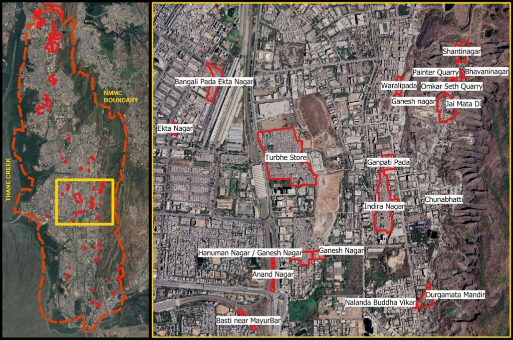
The DP acknowledges the Census 2011 slum list, however, the Existing Land Use maps published in 2018 that inform the Development Plan, are not available in the public domain.
The draft development plan report on housing and slums
The vision of the development plan, outlined in the report, is to achieve participative, stakeholder-friendly, growth-driven development and create ‘citizen-oriented’ policies. Among its 11 objectives, it clearly outlines minimising inequality, creating more housing stock that is within the reach of the common man and providing for redevelopment of slums.
The report goes on to acknowledge a deficit of 92,084 houses as per the city’s population in 2011 and notes the need for a housing stock to meet the needs by 2038. In particular it refers to the emerging needs of those living in slums, gaothans, gaothan expansion areas and old buildings. It mentions the need for redevelopment and the need to have reasonable levels of amenities. It notes that this requires an increase in urban land for housing and also policies to create more housing stock. It states that this is taken care of in the present Development Plan. The report also delineates a proposed land use reservation for ‘Slum Improvement Zone’ on 0.9% of the city’s land measuring 0.98 sq km.
While ostensibly these are useful aims, these ideals and ideas unfortunately quickly seem to dissolve in the proposed land use maps.
What the proposed land use maps reveal
While the report has relied on the 2011 Census list that lists 47 slums within Navi Mumbai; of the 47 only 11 slums (23%) are within the jurisdiction of the NMMC planning boundary. Of bigger concern is that only 4 slums in the Vashi-Turbhe area (Turbhe Stores, Indira Nagar (part), Ganpati Pada, Warli Pada, Hanuman Nagar) are on land belonging to the state government. 36 slums are on land belonging to MIDC and CIDCO. Of the 76 slums identified in the 2022 YUVA-GHSS survey, only 28 lie in the NMMC planning area. Given that MIDC and CIDCO are Special Planning Authorities, the future of the majority of slums in the city remains in limbo.
An analysis of Proposed Land Use reservations on areas occupied by slums reflects the invisibilisation of slums — 48.7% area of slums are reserved as residential, 13.8% area of slums are reserved as forest, 13% area of slums are reserved as PlayGround and Recreation, 10.3% area is reserved as proposed roads. Further details are in Table 1. The ‘Slum Improvement Zone’, has not been included as a land use category in the proposed land use maps. The broad residential reservation in the proposed land use maps does not delineate this as a sub category.
When reservations are superimposed on existing slums, they fail to acknowledge their existence. When coupled with the multiple planning authorities that plan for these areas, they point to an unknown future and in many cases, potential evictions.
What the Development Control Regulations (DCRs) state
The Maharashtra Unified Development Control Promotion Regulation applicable to the NMMC planning area includes various forms of seemingly progressive housing options such as Inclusive Housing, Social Housing (Rental housing), Affordable Housing for EWS/LIG, Pradhan Mantri Awas Yojana for EWS/LIG. It also details the ‘Slum Improvement Zone’ as being included within ‘Residential R-1’ land use reservation and notes that it shall be developed as per the Slum Rehabilitation Scheme of the Maharashtra Slum Act (Ibid.).
The CIDCO DCRs for Navi Mumbai (1975), amended in 2016 for CIDCO areas, applicable to the CIDCO planning areas and plots, do not outline any clear provision for slum upgradation or rehabilitation. The MIDC DCRs (revised 2009) applicable to the MIDC planning areas, includes basic provisions on formal housing for industrial workers. Both DCRs however refer to ‘Group Housing Scheme’ and ‘Plotted Development Scheme’. These appear that they could allow for a body like the Slum Rehabilitation Authority, however clear rules for slums have not been spelt out. A 2020 GR however, does include SRS on Navi Mumbai and CIDCO land.
Through the UDCPR regulations for slums, one thing clear is that slum redevelopment and resultant slum TDR to be earned in the process, is a state wide tailor-made solution for existing slums that meet the cut-off date.
Ambiguous governance boundaries and land contestation
Powers as planning authority were delegated to NMMC partly in 1994 and 2008 when CIDCO handed over select plots to the NMMC. In 2017 CIDCO was appointed as Special Planning Authority (SPA) for select areas. Similarly, the MIDC is the SPA for the industrial areas. This shift of authorities has been gradual and coupled with land contestation, with CIDCO, MIDC and NMMC in the powerplay.
In the context of the draft DP, the proposed plan thus only considers planning for 7 nodes in the NMMC boundary, while the rest of the land parcels are viewed as separate domains. This not only excludes a large population residing in these areas but it also exacerbates the anxieties for their future. As a result, the urban local body (NMMC) which is deemed to develop a cohesive DP for the region, has excluded large parcels of land resulting in a disjunct planning proposal.
An analysis of planning areas shows that MIDC currently accounts for 17% (approx 25 sq km) of Navi Mumbai while CIDCO accounts for large swathes measuring 10 sq km and many smaller plots within nodes. This percentage is high — the report mentions 975 plots that are yet to be handed over to NMMC and that 90% of land in Navi Mumbai is owned by CIDCO. During the preparation of the current DP that began in 2017, the Urban Development Department and CIDCO have raised concerns regarding the plan. As per objection raised by CIDCO, the Government of Maharashtra issued directions to NMMC in 2021 not to propose reservation on any plot owned by CIDCO measuring more than 500 sq.m.
This complexity has had severe repercussions on slums that lie on these ambiguous land boundaries. Most households in slums exist on insecure tenure and lack formal land documentation, in spite of having existed for decades. Land contestations interfere with people’s efforts to gain any form of formal documentation from authorities. This land division has furthered what Shirish Patel, one the chief architects of Navi Mumbai, terms as the ‘balkanisation of planning’ where no single authority is able to holistically plan for a city. Perhaps in such situations, in the guise of ambiguity, it becomes convenient for the authorities to side-line issue of the urban poor.
Ways forward
As the future for India’s largest planned city is being decided for the next two decades, it needs to acknowledge its present. The development plan 2018–2038 is about people who have come to inhabit the city. There must be a participative, inclusive process that acknowledges the contribution of thousands of workers who have built and continue to sustain it. It must account for their habitats by counting the numbers of slums accurately, reserve land occupied by existing slums under the ‘Slum improvement zone’ reservation or under a ‘Public Housing’ reservation where there must be options for self-development and upgradation, beyond the Slum Rehabilitation Scheme that has not seen much success at creating adequate habitats. It must include options for rental housing for migrant families.
If Navi Mumbai is to continue to show Indian cities the way to develop and be an inspiration to further endeavours in planning, it must showcase a way to include slums and the needs they represent even in planned cities. Navi Mumbai must chart its own plan, its own future, just like it did 50 years ago. Most importantly, its elected body must be given the power to do so.
[/vc_column_text][/vc_column][/vc_row]
Nearly a decade later, in 2022 YUVA and Ghar Haq Sangharsh Samiti (GHSS) conducted a geo-tagged mapping of slums in Navi Mumbai, with an intent to document existing slum settlements in the city. This survey located 76 settlements on an estimated 2% of the city’s land.
The DP acknowledges the Census 2011 slum list, however, the Existing Land Use maps published in 2018 that inform the Development Plan, are not available in the public domain.
The draft development plan report on housing and slums
The vision of the development plan, outlined in the report, is to achieve participative, stakeholder-friendly, growth-driven development and create ‘citizen-oriented’ policies. Among its 11 objectives, it clearly outlines minimising inequality, creating more housing stock that is within the reach of the common man and providing for redevelopment of slums.
The report goes on to acknowledge a deficit of 92,084 houses as per the city’s population in 2011 and notes the need for a housing stock to meet the needs by 2038. In particular it refers to the emerging needs of those living in slums, gaothans, gaothan expansion areas and old buildings. It mentions the need for redevelopment and the need to have reasonable levels of amenities. It notes that this requires an increase in urban land for housing and also policies to create more housing stock. It states that this is taken care of in the present Development Plan. The report also delineates a proposed land use reservation for ‘Slum Improvement Zone’ on 0.9% of the city’s land measuring 0.98 sq km.
While ostensibly these are useful aims, these ideals and ideas unfortunately quickly seem to dissolve in the proposed land use maps.
What the proposed land use maps reveal
While the report has relied on the 2011 Census list that lists 47 slums within Navi Mumbai; of the 47 only 11 slums (23%) are within the jurisdiction of the NMMC planning boundary. Of bigger concern is that only 4 slums in the Vashi-Turbhe area (Turbhe Stores, Indira Nagar (part), Ganpati Pada, Warli Pada, Hanuman Nagar) are on land belonging to the state government. 36 slums are on land belonging to MIDC and CIDCO. Of the 76 slums identified in the 2022 YUVA-GHSS survey, only 28 lie in the NMMC planning area. Given that MIDC and CIDCO are Special Planning Authorities, the future of the majority of slums in the city remains in limbo.
An analysis of Proposed Land Use reservations on areas occupied by slums reflects the invisibilisation of slums — 48.7% area of slums are reserved as residential, 13.8% area of slums are reserved as forest, 13% area of slums are reserved as PlayGround and Recreation, 10.3% area is reserved as proposed roads. Further details are in Table 1. The ‘Slum Improvement Zone’, has not been included as a land use category in the proposed land use maps. The broad residential reservation in the proposed land use maps does not delineate this as a sub category.
When reservations are superimposed on existing slums, they fail to acknowledge their existence. When coupled with the multiple planning authorities that plan for these areas, they point to an unknown future and in many cases, potential evictions.
What the Development Control Regulations (DCRs) state
The Maharashtra Unified Development Control Promotion Regulation applicable to the NMMC planning area includes various forms of seemingly progressive housing options such as Inclusive Housing, Social Housing (Rental housing), Affordable Housing for EWS/LIG, Pradhan Mantri Awas Yojana for EWS/LIG. It also details the ‘Slum Improvement Zone’ as being included within ‘Residential R-1’ land use reservation and notes that it shall be developed as per the Slum Rehabilitation Scheme of the Maharashtra Slum Act (Ibid.).
The CIDCO DCRs for Navi Mumbai (1975), amended in 2016 for CIDCO areas, applicable to the CIDCO planning areas and plots, do not outline any clear provision for slum upgradation or rehabilitation. The MIDC DCRs (revised 2009) applicable to the MIDC planning areas, includes basic provisions on formal housing for industrial workers. Both DCRs however refer to ‘Group Housing Scheme’ and ‘Plotted Development Scheme’. These appear that they could allow for a body like the Slum Rehabilitation Authority, however clear rules for slums have not been spelt out. A 2020 GR however, does include SRS on Navi Mumbai and CIDCO land.
Through the UDCPR regulations for slums, one thing clear is that slum redevelopment and resultant slum TDR to be earned in the process, is a state wide tailor-made solution for existing slums that meet the cut-off date.
Ambiguous governance boundaries and land contestation
Powers as planning authority were delegated to NMMC partly in 1994 and 2008 when CIDCO handed over select plots to the NMMC. In 2017 CIDCO was appointed as Special Planning Authority (SPA) for select areas. Similarly, the MIDC is the SPA for the industrial areas. This shift of authorities has been gradual and coupled with land contestation, with CIDCO, MIDC and NMMC in the powerplay.
In the context of the draft DP, the proposed plan thus only considers planning for 7 nodes in the NMMC boundary, while the rest of the land parcels are viewed as separate domains. This not only excludes a large population residing in these areas but it also exacerbates the anxieties for their future. As a result, the urban local body (NMMC) which is deemed to develop a cohesive DP for the region, has excluded large parcels of land resulting in a disjunct planning proposal.
An analysis of planning areas shows that MIDC currently accounts for 17% (approx 25 sq km) of Navi Mumbai while CIDCO accounts for large swathes measuring 10 sq km and many smaller plots within nodes. This percentage is high — the report mentions 975 plots that are yet to be handed over to NMMC and that 90% of land in Navi Mumbai is owned by CIDCO. During the preparation of the current DP that began in 2017, the Urban Development Department and CIDCO have raised concerns regarding the plan. As per objection raised by CIDCO, the Government of Maharashtra issued directions to NMMC in 2021 not to propose reservation on any plot owned by CIDCO measuring more than 500 sq.m.
This complexity has had severe repercussions on slums that lie on these ambiguous land boundaries. Most households in slums exist on insecure tenure and lack formal land documentation, in spite of having existed for decades. Land contestations interfere with people’s efforts to gain any form of formal documentation from authorities. This land division has furthered what Shirish Patel, one the chief architects of Navi Mumbai, terms as the ‘balkanisation of planning’ where no single authority is able to holistically plan for a city. Perhaps in such situations, in the guise of ambiguity, it becomes convenient for the authorities to side-line issue of the urban poor.
Ways forward
As the future for India’s largest planned city is being decided for the next two decades, it needs to acknowledge its present. The development plan 2018–2038 is about people who have come to inhabit the city. There must be a participative, inclusive process that acknowledges the contribution of thousands of workers who have built and continue to sustain it. It must account for their habitats by counting the numbers of slums accurately, reserve land occupied by existing slums under the ‘Slum improvement zone’ reservation or under a ‘Public Housing’ reservation where there must be options for self-development and upgradation, beyond the Slum Rehabilitation Scheme that has not seen much success at creating adequate habitats. It must include options for rental housing for migrant families.
If Navi Mumbai is to continue to show Indian cities the way to develop and be an inspiration to further endeavours in planning, it must showcase a way to include slums and the needs they represent even in planned cities. Navi Mumbai must chart its own plan, its own future, just like it did 50 years ago. Most importantly, its elected body must be given the power to do so.
[/vc_column_text][/vc_column][/vc_row]
As of 2011, the population of Navi Mumbai was 11.2 lakhs including a slum population of 2.08 lakhs living in 67,327 households in 47 slums. Within which 64% owned their homes, 33% lived on rent and 3 percent lived at their work premises or on the streets. Among these residents, the Scheduled Caste population was 8.93 per cent and the Scheduled Tribe population was 1.6 per cent. There are also Nomadic Tribes who have migrated from various places due to drought, floods and no land holdings and employment in villages.
Nearly a decade later, in 2022 YUVA and Ghar Haq Sangharsh Samiti (GHSS) conducted a geo-tagged mapping of slums in Navi Mumbai, with an intent to document existing slum settlements in the city. This survey located 76 settlements on an estimated 2% of the city’s land.
The DP acknowledges the Census 2011 slum list, however, the Existing Land Use maps published in 2018 that inform the Development Plan, are not available in the public domain.
The draft development plan report on housing and slums
The vision of the development plan, outlined in the report, is to achieve participative, stakeholder-friendly, growth-driven development and create ‘citizen-oriented’ policies. Among its 11 objectives, it clearly outlines minimising inequality, creating more housing stock that is within the reach of the common man and providing for redevelopment of slums.
The report goes on to acknowledge a deficit of 92,084 houses as per the city’s population in 2011 and notes the need for a housing stock to meet the needs by 2038. In particular it refers to the emerging needs of those living in slums, gaothans, gaothan expansion areas and old buildings. It mentions the need for redevelopment and the need to have reasonable levels of amenities. It notes that this requires an increase in urban land for housing and also policies to create more housing stock. It states that this is taken care of in the present Development Plan. The report also delineates a proposed land use reservation for ‘Slum Improvement Zone’ on 0.9% of the city’s land measuring 0.98 sq km.
While ostensibly these are useful aims, these ideals and ideas unfortunately quickly seem to dissolve in the proposed land use maps.
What the proposed land use maps reveal
While the report has relied on the 2011 Census list that lists 47 slums within Navi Mumbai; of the 47 only 11 slums (23%) are within the jurisdiction of the NMMC planning boundary. Of bigger concern is that only 4 slums in the Vashi-Turbhe area (Turbhe Stores, Indira Nagar (part), Ganpati Pada, Warli Pada, Hanuman Nagar) are on land belonging to the state government. 36 slums are on land belonging to MIDC and CIDCO. Of the 76 slums identified in the 2022 YUVA-GHSS survey, only 28 lie in the NMMC planning area. Given that MIDC and CIDCO are Special Planning Authorities, the future of the majority of slums in the city remains in limbo.
An analysis of Proposed Land Use reservations on areas occupied by slums reflects the invisibilisation of slums — 48.7% area of slums are reserved as residential, 13.8% area of slums are reserved as forest, 13% area of slums are reserved as PlayGround and Recreation, 10.3% area is reserved as proposed roads. Further details are in Table 1. The ‘Slum Improvement Zone’, has not been included as a land use category in the proposed land use maps. The broad residential reservation in the proposed land use maps does not delineate this as a sub category.
When reservations are superimposed on existing slums, they fail to acknowledge their existence. When coupled with the multiple planning authorities that plan for these areas, they point to an unknown future and in many cases, potential evictions.
What the Development Control Regulations (DCRs) state
The Maharashtra Unified Development Control Promotion Regulation applicable to the NMMC planning area includes various forms of seemingly progressive housing options such as Inclusive Housing, Social Housing (Rental housing), Affordable Housing for EWS/LIG, Pradhan Mantri Awas Yojana for EWS/LIG. It also details the ‘Slum Improvement Zone’ as being included within ‘Residential R-1’ land use reservation and notes that it shall be developed as per the Slum Rehabilitation Scheme of the Maharashtra Slum Act (Ibid.).
The CIDCO DCRs for Navi Mumbai (1975), amended in 2016 for CIDCO areas, applicable to the CIDCO planning areas and plots, do not outline any clear provision for slum upgradation or rehabilitation. The MIDC DCRs (revised 2009) applicable to the MIDC planning areas, includes basic provisions on formal housing for industrial workers. Both DCRs however refer to ‘Group Housing Scheme’ and ‘Plotted Development Scheme’. These appear that they could allow for a body like the Slum Rehabilitation Authority, however clear rules for slums have not been spelt out. A 2020 GR however, does include SRS on Navi Mumbai and CIDCO land.
Through the UDCPR regulations for slums, one thing clear is that slum redevelopment and resultant slum TDR to be earned in the process, is a state wide tailor-made solution for existing slums that meet the cut-off date.
Ambiguous governance boundaries and land contestation
Powers as planning authority were delegated to NMMC partly in 1994 and 2008 when CIDCO handed over select plots to the NMMC. In 2017 CIDCO was appointed as Special Planning Authority (SPA) for select areas. Similarly, the MIDC is the SPA for the industrial areas. This shift of authorities has been gradual and coupled with land contestation, with CIDCO, MIDC and NMMC in the powerplay.
In the context of the draft DP, the proposed plan thus only considers planning for 7 nodes in the NMMC boundary, while the rest of the land parcels are viewed as separate domains. This not only excludes a large population residing in these areas but it also exacerbates the anxieties for their future. As a result, the urban local body (NMMC) which is deemed to develop a cohesive DP for the region, has excluded large parcels of land resulting in a disjunct planning proposal.
An analysis of planning areas shows that MIDC currently accounts for 17% (approx 25 sq km) of Navi Mumbai while CIDCO accounts for large swathes measuring 10 sq km and many smaller plots within nodes. This percentage is high — the report mentions 975 plots that are yet to be handed over to NMMC and that 90% of land in Navi Mumbai is owned by CIDCO. During the preparation of the current DP that began in 2017, the Urban Development Department and CIDCO have raised concerns regarding the plan. As per objection raised by CIDCO, the Government of Maharashtra issued directions to NMMC in 2021 not to propose reservation on any plot owned by CIDCO measuring more than 500 sq.m.
This complexity has had severe repercussions on slums that lie on these ambiguous land boundaries. Most households in slums exist on insecure tenure and lack formal land documentation, in spite of having existed for decades. Land contestations interfere with people’s efforts to gain any form of formal documentation from authorities. This land division has furthered what Shirish Patel, one the chief architects of Navi Mumbai, terms as the ‘balkanisation of planning’ where no single authority is able to holistically plan for a city. Perhaps in such situations, in the guise of ambiguity, it becomes convenient for the authorities to side-line issue of the urban poor.
Ways forward
As the future for India’s largest planned city is being decided for the next two decades, it needs to acknowledge its present. The development plan 2018–2038 is about people who have come to inhabit the city. There must be a participative, inclusive process that acknowledges the contribution of thousands of workers who have built and continue to sustain it. It must account for their habitats by counting the numbers of slums accurately, reserve land occupied by existing slums under the ‘Slum improvement zone’ reservation or under a ‘Public Housing’ reservation where there must be options for self-development and upgradation, beyond the Slum Rehabilitation Scheme that has not seen much success at creating adequate habitats. It must include options for rental housing for migrant families.
If Navi Mumbai is to continue to show Indian cities the way to develop and be an inspiration to further endeavours in planning, it must showcase a way to include slums and the needs they represent even in planned cities. Navi Mumbai must chart its own plan, its own future, just like it did 50 years ago. Most importantly, its elected body must be given the power to do so.
[/vc_column_text][/vc_column][/vc_row]
The city, for over a span of 30 years, was built by informal workers, of which majority (51%) were from Maharashtra. Their low wages, coupled with a lack of documentation, kept them away from the planned EWS/LIG (economically weaker section, low-income group) housing developed by CIDCO. A survey conducted in select slums in 2017, showed that the highest employment sectors were construction work, domestic worker and street vending. The survey also revealed that the concentration of earning members in select slums in Navi Mumbai, was high at the lower side of the income quintile, from INR 3,000–10,000, only 5.7 per cent earned over INR 10,000 per month. As a result, they developed informal settlements as a solution to their housing needs which were unmet by the city. These settlements lack basic amenities and many have faced repeated evictions (Ibid.). Some of these slums have existed for over 30 years, even prior to the formation of the NMMC. Over time, NMMC and CIDCO have attempted to provide some respite by providing services to these settlements. In 2020, a Government Resolution also extended the Slum Rehabilitation Scheme to cities in the Mumbai Metropolitan Region including Navi Mumbai and CIDCO areas.
As of 2011, the population of Navi Mumbai was 11.2 lakhs including a slum population of 2.08 lakhs living in 67,327 households in 47 slums. Within which 64% owned their homes, 33% lived on rent and 3 percent lived at their work premises or on the streets. Among these residents, the Scheduled Caste population was 8.93 per cent and the Scheduled Tribe population was 1.6 per cent. There are also Nomadic Tribes who have migrated from various places due to drought, floods and no land holdings and employment in villages.
Nearly a decade later, in 2022 YUVA and Ghar Haq Sangharsh Samiti (GHSS) conducted a geo-tagged mapping of slums in Navi Mumbai, with an intent to document existing slum settlements in the city. This survey located 76 settlements on an estimated 2% of the city’s land.
The DP acknowledges the Census 2011 slum list, however, the Existing Land Use maps published in 2018 that inform the Development Plan, are not available in the public domain.
The draft development plan report on housing and slums
The vision of the development plan, outlined in the report, is to achieve participative, stakeholder-friendly, growth-driven development and create ‘citizen-oriented’ policies. Among its 11 objectives, it clearly outlines minimising inequality, creating more housing stock that is within the reach of the common man and providing for redevelopment of slums.
The report goes on to acknowledge a deficit of 92,084 houses as per the city’s population in 2011 and notes the need for a housing stock to meet the needs by 2038. In particular it refers to the emerging needs of those living in slums, gaothans, gaothan expansion areas and old buildings. It mentions the need for redevelopment and the need to have reasonable levels of amenities. It notes that this requires an increase in urban land for housing and also policies to create more housing stock. It states that this is taken care of in the present Development Plan. The report also delineates a proposed land use reservation for ‘Slum Improvement Zone’ on 0.9% of the city’s land measuring 0.98 sq km.
While ostensibly these are useful aims, these ideals and ideas unfortunately quickly seem to dissolve in the proposed land use maps.
What the proposed land use maps reveal
While the report has relied on the 2011 Census list that lists 47 slums within Navi Mumbai; of the 47 only 11 slums (23%) are within the jurisdiction of the NMMC planning boundary. Of bigger concern is that only 4 slums in the Vashi-Turbhe area (Turbhe Stores, Indira Nagar (part), Ganpati Pada, Warli Pada, Hanuman Nagar) are on land belonging to the state government. 36 slums are on land belonging to MIDC and CIDCO. Of the 76 slums identified in the 2022 YUVA-GHSS survey, only 28 lie in the NMMC planning area. Given that MIDC and CIDCO are Special Planning Authorities, the future of the majority of slums in the city remains in limbo.
An analysis of Proposed Land Use reservations on areas occupied by slums reflects the invisibilisation of slums — 48.7% area of slums are reserved as residential, 13.8% area of slums are reserved as forest, 13% area of slums are reserved as PlayGround and Recreation, 10.3% area is reserved as proposed roads. Further details are in Table 1. The ‘Slum Improvement Zone’, has not been included as a land use category in the proposed land use maps. The broad residential reservation in the proposed land use maps does not delineate this as a sub category.
When reservations are superimposed on existing slums, they fail to acknowledge their existence. When coupled with the multiple planning authorities that plan for these areas, they point to an unknown future and in many cases, potential evictions.
What the Development Control Regulations (DCRs) state
The Maharashtra Unified Development Control Promotion Regulation applicable to the NMMC planning area includes various forms of seemingly progressive housing options such as Inclusive Housing, Social Housing (Rental housing), Affordable Housing for EWS/LIG, Pradhan Mantri Awas Yojana for EWS/LIG. It also details the ‘Slum Improvement Zone’ as being included within ‘Residential R-1’ land use reservation and notes that it shall be developed as per the Slum Rehabilitation Scheme of the Maharashtra Slum Act (Ibid.).
The CIDCO DCRs for Navi Mumbai (1975), amended in 2016 for CIDCO areas, applicable to the CIDCO planning areas and plots, do not outline any clear provision for slum upgradation or rehabilitation. The MIDC DCRs (revised 2009) applicable to the MIDC planning areas, includes basic provisions on formal housing for industrial workers. Both DCRs however refer to ‘Group Housing Scheme’ and ‘Plotted Development Scheme’. These appear that they could allow for a body like the Slum Rehabilitation Authority, however clear rules for slums have not been spelt out. A 2020 GR however, does include SRS on Navi Mumbai and CIDCO land.
Through the UDCPR regulations for slums, one thing clear is that slum redevelopment and resultant slum TDR to be earned in the process, is a state wide tailor-made solution for existing slums that meet the cut-off date.
Ambiguous governance boundaries and land contestation
Powers as planning authority were delegated to NMMC partly in 1994 and 2008 when CIDCO handed over select plots to the NMMC. In 2017 CIDCO was appointed as Special Planning Authority (SPA) for select areas. Similarly, the MIDC is the SPA for the industrial areas. This shift of authorities has been gradual and coupled with land contestation, with CIDCO, MIDC and NMMC in the powerplay.
In the context of the draft DP, the proposed plan thus only considers planning for 7 nodes in the NMMC boundary, while the rest of the land parcels are viewed as separate domains. This not only excludes a large population residing in these areas but it also exacerbates the anxieties for their future. As a result, the urban local body (NMMC) which is deemed to develop a cohesive DP for the region, has excluded large parcels of land resulting in a disjunct planning proposal.
An analysis of planning areas shows that MIDC currently accounts for 17% (approx 25 sq km) of Navi Mumbai while CIDCO accounts for large swathes measuring 10 sq km and many smaller plots within nodes. This percentage is high — the report mentions 975 plots that are yet to be handed over to NMMC and that 90% of land in Navi Mumbai is owned by CIDCO. During the preparation of the current DP that began in 2017, the Urban Development Department and CIDCO have raised concerns regarding the plan. As per objection raised by CIDCO, the Government of Maharashtra issued directions to NMMC in 2021 not to propose reservation on any plot owned by CIDCO measuring more than 500 sq.m.
This complexity has had severe repercussions on slums that lie on these ambiguous land boundaries. Most households in slums exist on insecure tenure and lack formal land documentation, in spite of having existed for decades. Land contestations interfere with people’s efforts to gain any form of formal documentation from authorities. This land division has furthered what Shirish Patel, one the chief architects of Navi Mumbai, terms as the ‘balkanisation of planning’ where no single authority is able to holistically plan for a city. Perhaps in such situations, in the guise of ambiguity, it becomes convenient for the authorities to side-line issue of the urban poor.
Ways forward
As the future for India’s largest planned city is being decided for the next two decades, it needs to acknowledge its present. The development plan 2018–2038 is about people who have come to inhabit the city. There must be a participative, inclusive process that acknowledges the contribution of thousands of workers who have built and continue to sustain it. It must account for their habitats by counting the numbers of slums accurately, reserve land occupied by existing slums under the ‘Slum improvement zone’ reservation or under a ‘Public Housing’ reservation where there must be options for self-development and upgradation, beyond the Slum Rehabilitation Scheme that has not seen much success at creating adequate habitats. It must include options for rental housing for migrant families.
If Navi Mumbai is to continue to show Indian cities the way to develop and be an inspiration to further endeavours in planning, it must showcase a way to include slums and the needs they represent even in planned cities. Navi Mumbai must chart its own plan, its own future, just like it did 50 years ago. Most importantly, its elected body must be given the power to do so.
[/vc_column_text][/vc_column][/vc_row]
18% of residents in the planned city live in slums
The city, for over a span of 30 years, was built by informal workers, of which majority (51%) were from Maharashtra. Their low wages, coupled with a lack of documentation, kept them away from the planned EWS/LIG (economically weaker section, low-income group) housing developed by CIDCO. A survey conducted in select slums in 2017, showed that the highest employment sectors were construction work, domestic worker and street vending. The survey also revealed that the concentration of earning members in select slums in Navi Mumbai, was high at the lower side of the income quintile, from INR 3,000–10,000, only 5.7 per cent earned over INR 10,000 per month. As a result, they developed informal settlements as a solution to their housing needs which were unmet by the city. These settlements lack basic amenities and many have faced repeated evictions (Ibid.). Some of these slums have existed for over 30 years, even prior to the formation of the NMMC. Over time, NMMC and CIDCO have attempted to provide some respite by providing services to these settlements. In 2020, a Government Resolution also extended the Slum Rehabilitation Scheme to cities in the Mumbai Metropolitan Region including Navi Mumbai and CIDCO areas.
As of 2011, the population of Navi Mumbai was 11.2 lakhs including a slum population of 2.08 lakhs living in 67,327 households in 47 slums. Within which 64% owned their homes, 33% lived on rent and 3 percent lived at their work premises or on the streets. Among these residents, the Scheduled Caste population was 8.93 per cent and the Scheduled Tribe population was 1.6 per cent. There are also Nomadic Tribes who have migrated from various places due to drought, floods and no land holdings and employment in villages.
Nearly a decade later, in 2022 YUVA and Ghar Haq Sangharsh Samiti (GHSS) conducted a geo-tagged mapping of slums in Navi Mumbai, with an intent to document existing slum settlements in the city. This survey located 76 settlements on an estimated 2% of the city’s land.
The DP acknowledges the Census 2011 slum list, however, the Existing Land Use maps published in 2018 that inform the Development Plan, are not available in the public domain.
The draft development plan report on housing and slums
The vision of the development plan, outlined in the report, is to achieve participative, stakeholder-friendly, growth-driven development and create ‘citizen-oriented’ policies. Among its 11 objectives, it clearly outlines minimising inequality, creating more housing stock that is within the reach of the common man and providing for redevelopment of slums.
The report goes on to acknowledge a deficit of 92,084 houses as per the city’s population in 2011 and notes the need for a housing stock to meet the needs by 2038. In particular it refers to the emerging needs of those living in slums, gaothans, gaothan expansion areas and old buildings. It mentions the need for redevelopment and the need to have reasonable levels of amenities. It notes that this requires an increase in urban land for housing and also policies to create more housing stock. It states that this is taken care of in the present Development Plan. The report also delineates a proposed land use reservation for ‘Slum Improvement Zone’ on 0.9% of the city’s land measuring 0.98 sq km.
While ostensibly these are useful aims, these ideals and ideas unfortunately quickly seem to dissolve in the proposed land use maps.
What the proposed land use maps reveal
While the report has relied on the 2011 Census list that lists 47 slums within Navi Mumbai; of the 47 only 11 slums (23%) are within the jurisdiction of the NMMC planning boundary. Of bigger concern is that only 4 slums in the Vashi-Turbhe area (Turbhe Stores, Indira Nagar (part), Ganpati Pada, Warli Pada, Hanuman Nagar) are on land belonging to the state government. 36 slums are on land belonging to MIDC and CIDCO. Of the 76 slums identified in the 2022 YUVA-GHSS survey, only 28 lie in the NMMC planning area. Given that MIDC and CIDCO are Special Planning Authorities, the future of the majority of slums in the city remains in limbo.
An analysis of Proposed Land Use reservations on areas occupied by slums reflects the invisibilisation of slums — 48.7% area of slums are reserved as residential, 13.8% area of slums are reserved as forest, 13% area of slums are reserved as PlayGround and Recreation, 10.3% area is reserved as proposed roads. Further details are in Table 1. The ‘Slum Improvement Zone’, has not been included as a land use category in the proposed land use maps. The broad residential reservation in the proposed land use maps does not delineate this as a sub category.
When reservations are superimposed on existing slums, they fail to acknowledge their existence. When coupled with the multiple planning authorities that plan for these areas, they point to an unknown future and in many cases, potential evictions.
What the Development Control Regulations (DCRs) state
The Maharashtra Unified Development Control Promotion Regulation applicable to the NMMC planning area includes various forms of seemingly progressive housing options such as Inclusive Housing, Social Housing (Rental housing), Affordable Housing for EWS/LIG, Pradhan Mantri Awas Yojana for EWS/LIG. It also details the ‘Slum Improvement Zone’ as being included within ‘Residential R-1’ land use reservation and notes that it shall be developed as per the Slum Rehabilitation Scheme of the Maharashtra Slum Act (Ibid.).
The CIDCO DCRs for Navi Mumbai (1975), amended in 2016 for CIDCO areas, applicable to the CIDCO planning areas and plots, do not outline any clear provision for slum upgradation or rehabilitation. The MIDC DCRs (revised 2009) applicable to the MIDC planning areas, includes basic provisions on formal housing for industrial workers. Both DCRs however refer to ‘Group Housing Scheme’ and ‘Plotted Development Scheme’. These appear that they could allow for a body like the Slum Rehabilitation Authority, however clear rules for slums have not been spelt out. A 2020 GR however, does include SRS on Navi Mumbai and CIDCO land.
Through the UDCPR regulations for slums, one thing clear is that slum redevelopment and resultant slum TDR to be earned in the process, is a state wide tailor-made solution for existing slums that meet the cut-off date.
Ambiguous governance boundaries and land contestation
Powers as planning authority were delegated to NMMC partly in 1994 and 2008 when CIDCO handed over select plots to the NMMC. In 2017 CIDCO was appointed as Special Planning Authority (SPA) for select areas. Similarly, the MIDC is the SPA for the industrial areas. This shift of authorities has been gradual and coupled with land contestation, with CIDCO, MIDC and NMMC in the powerplay.
In the context of the draft DP, the proposed plan thus only considers planning for 7 nodes in the NMMC boundary, while the rest of the land parcels are viewed as separate domains. This not only excludes a large population residing in these areas but it also exacerbates the anxieties for their future. As a result, the urban local body (NMMC) which is deemed to develop a cohesive DP for the region, has excluded large parcels of land resulting in a disjunct planning proposal.
An analysis of planning areas shows that MIDC currently accounts for 17% (approx 25 sq km) of Navi Mumbai while CIDCO accounts for large swathes measuring 10 sq km and many smaller plots within nodes. This percentage is high — the report mentions 975 plots that are yet to be handed over to NMMC and that 90% of land in Navi Mumbai is owned by CIDCO. During the preparation of the current DP that began in 2017, the Urban Development Department and CIDCO have raised concerns regarding the plan. As per objection raised by CIDCO, the Government of Maharashtra issued directions to NMMC in 2021 not to propose reservation on any plot owned by CIDCO measuring more than 500 sq.m.
This complexity has had severe repercussions on slums that lie on these ambiguous land boundaries. Most households in slums exist on insecure tenure and lack formal land documentation, in spite of having existed for decades. Land contestations interfere with people’s efforts to gain any form of formal documentation from authorities. This land division has furthered what Shirish Patel, one the chief architects of Navi Mumbai, terms as the ‘balkanisation of planning’ where no single authority is able to holistically plan for a city. Perhaps in such situations, in the guise of ambiguity, it becomes convenient for the authorities to side-line issue of the urban poor.
Ways forward
As the future for India’s largest planned city is being decided for the next two decades, it needs to acknowledge its present. The development plan 2018–2038 is about people who have come to inhabit the city. There must be a participative, inclusive process that acknowledges the contribution of thousands of workers who have built and continue to sustain it. It must account for their habitats by counting the numbers of slums accurately, reserve land occupied by existing slums under the ‘Slum improvement zone’ reservation or under a ‘Public Housing’ reservation where there must be options for self-development and upgradation, beyond the Slum Rehabilitation Scheme that has not seen much success at creating adequate habitats. It must include options for rental housing for migrant families.
If Navi Mumbai is to continue to show Indian cities the way to develop and be an inspiration to further endeavours in planning, it must showcase a way to include slums and the needs they represent even in planned cities. Navi Mumbai must chart its own plan, its own future, just like it did 50 years ago. Most importantly, its elected body must be given the power to do so.
[/vc_column_text][/vc_column][/vc_row]
As the city grew and consolidated, in 1992, the NMMC was formed to govern the new city. It currently houses a population of an estimated 18 lakh over 190 sq km. Out of the total 343 sq km acquired for the Navi Mumbai project, 109 sq km lie in the NMMC boundary, the rest has been divided into present day Panvel Municipal Corporation, Khopta New Town, NAINA, etc. By 2038 the city is projected to house a population of 28 lakhs (Ibid.).
18% of residents in the planned city live in slums
The city, for over a span of 30 years, was built by informal workers, of which majority (51%) were from Maharashtra. Their low wages, coupled with a lack of documentation, kept them away from the planned EWS/LIG (economically weaker section, low-income group) housing developed by CIDCO. A survey conducted in select slums in 2017, showed that the highest employment sectors were construction work, domestic worker and street vending. The survey also revealed that the concentration of earning members in select slums in Navi Mumbai, was high at the lower side of the income quintile, from INR 3,000–10,000, only 5.7 per cent earned over INR 10,000 per month. As a result, they developed informal settlements as a solution to their housing needs which were unmet by the city. These settlements lack basic amenities and many have faced repeated evictions (Ibid.). Some of these slums have existed for over 30 years, even prior to the formation of the NMMC. Over time, NMMC and CIDCO have attempted to provide some respite by providing services to these settlements. In 2020, a Government Resolution also extended the Slum Rehabilitation Scheme to cities in the Mumbai Metropolitan Region including Navi Mumbai and CIDCO areas.
As of 2011, the population of Navi Mumbai was 11.2 lakhs including a slum population of 2.08 lakhs living in 67,327 households in 47 slums. Within which 64% owned their homes, 33% lived on rent and 3 percent lived at their work premises or on the streets. Among these residents, the Scheduled Caste population was 8.93 per cent and the Scheduled Tribe population was 1.6 per cent. There are also Nomadic Tribes who have migrated from various places due to drought, floods and no land holdings and employment in villages.
Nearly a decade later, in 2022 YUVA and Ghar Haq Sangharsh Samiti (GHSS) conducted a geo-tagged mapping of slums in Navi Mumbai, with an intent to document existing slum settlements in the city. This survey located 76 settlements on an estimated 2% of the city’s land.
The DP acknowledges the Census 2011 slum list, however, the Existing Land Use maps published in 2018 that inform the Development Plan, are not available in the public domain.
The draft development plan report on housing and slums
The vision of the development plan, outlined in the report, is to achieve participative, stakeholder-friendly, growth-driven development and create ‘citizen-oriented’ policies. Among its 11 objectives, it clearly outlines minimising inequality, creating more housing stock that is within the reach of the common man and providing for redevelopment of slums.
The report goes on to acknowledge a deficit of 92,084 houses as per the city’s population in 2011 and notes the need for a housing stock to meet the needs by 2038. In particular it refers to the emerging needs of those living in slums, gaothans, gaothan expansion areas and old buildings. It mentions the need for redevelopment and the need to have reasonable levels of amenities. It notes that this requires an increase in urban land for housing and also policies to create more housing stock. It states that this is taken care of in the present Development Plan. The report also delineates a proposed land use reservation for ‘Slum Improvement Zone’ on 0.9% of the city’s land measuring 0.98 sq km.
While ostensibly these are useful aims, these ideals and ideas unfortunately quickly seem to dissolve in the proposed land use maps.
What the proposed land use maps reveal
While the report has relied on the 2011 Census list that lists 47 slums within Navi Mumbai; of the 47 only 11 slums (23%) are within the jurisdiction of the NMMC planning boundary. Of bigger concern is that only 4 slums in the Vashi-Turbhe area (Turbhe Stores, Indira Nagar (part), Ganpati Pada, Warli Pada, Hanuman Nagar) are on land belonging to the state government. 36 slums are on land belonging to MIDC and CIDCO. Of the 76 slums identified in the 2022 YUVA-GHSS survey, only 28 lie in the NMMC planning area. Given that MIDC and CIDCO are Special Planning Authorities, the future of the majority of slums in the city remains in limbo.
An analysis of Proposed Land Use reservations on areas occupied by slums reflects the invisibilisation of slums — 48.7% area of slums are reserved as residential, 13.8% area of slums are reserved as forest, 13% area of slums are reserved as PlayGround and Recreation, 10.3% area is reserved as proposed roads. Further details are in Table 1. The ‘Slum Improvement Zone’, has not been included as a land use category in the proposed land use maps. The broad residential reservation in the proposed land use maps does not delineate this as a sub category.
When reservations are superimposed on existing slums, they fail to acknowledge their existence. When coupled with the multiple planning authorities that plan for these areas, they point to an unknown future and in many cases, potential evictions.
What the Development Control Regulations (DCRs) state
The Maharashtra Unified Development Control Promotion Regulation applicable to the NMMC planning area includes various forms of seemingly progressive housing options such as Inclusive Housing, Social Housing (Rental housing), Affordable Housing for EWS/LIG, Pradhan Mantri Awas Yojana for EWS/LIG. It also details the ‘Slum Improvement Zone’ as being included within ‘Residential R-1’ land use reservation and notes that it shall be developed as per the Slum Rehabilitation Scheme of the Maharashtra Slum Act (Ibid.).
The CIDCO DCRs for Navi Mumbai (1975), amended in 2016 for CIDCO areas, applicable to the CIDCO planning areas and plots, do not outline any clear provision for slum upgradation or rehabilitation. The MIDC DCRs (revised 2009) applicable to the MIDC planning areas, includes basic provisions on formal housing for industrial workers. Both DCRs however refer to ‘Group Housing Scheme’ and ‘Plotted Development Scheme’. These appear that they could allow for a body like the Slum Rehabilitation Authority, however clear rules for slums have not been spelt out. A 2020 GR however, does include SRS on Navi Mumbai and CIDCO land.
Through the UDCPR regulations for slums, one thing clear is that slum redevelopment and resultant slum TDR to be earned in the process, is a state wide tailor-made solution for existing slums that meet the cut-off date.
Ambiguous governance boundaries and land contestation
Powers as planning authority were delegated to NMMC partly in 1994 and 2008 when CIDCO handed over select plots to the NMMC. In 2017 CIDCO was appointed as Special Planning Authority (SPA) for select areas. Similarly, the MIDC is the SPA for the industrial areas. This shift of authorities has been gradual and coupled with land contestation, with CIDCO, MIDC and NMMC in the powerplay.
In the context of the draft DP, the proposed plan thus only considers planning for 7 nodes in the NMMC boundary, while the rest of the land parcels are viewed as separate domains. This not only excludes a large population residing in these areas but it also exacerbates the anxieties for their future. As a result, the urban local body (NMMC) which is deemed to develop a cohesive DP for the region, has excluded large parcels of land resulting in a disjunct planning proposal.
An analysis of planning areas shows that MIDC currently accounts for 17% (approx 25 sq km) of Navi Mumbai while CIDCO accounts for large swathes measuring 10 sq km and many smaller plots within nodes. This percentage is high — the report mentions 975 plots that are yet to be handed over to NMMC and that 90% of land in Navi Mumbai is owned by CIDCO. During the preparation of the current DP that began in 2017, the Urban Development Department and CIDCO have raised concerns regarding the plan. As per objection raised by CIDCO, the Government of Maharashtra issued directions to NMMC in 2021 not to propose reservation on any plot owned by CIDCO measuring more than 500 sq.m.
This complexity has had severe repercussions on slums that lie on these ambiguous land boundaries. Most households in slums exist on insecure tenure and lack formal land documentation, in spite of having existed for decades. Land contestations interfere with people’s efforts to gain any form of formal documentation from authorities. This land division has furthered what Shirish Patel, one the chief architects of Navi Mumbai, terms as the ‘balkanisation of planning’ where no single authority is able to holistically plan for a city. Perhaps in such situations, in the guise of ambiguity, it becomes convenient for the authorities to side-line issue of the urban poor.
Ways forward
As the future for India’s largest planned city is being decided for the next two decades, it needs to acknowledge its present. The development plan 2018–2038 is about people who have come to inhabit the city. There must be a participative, inclusive process that acknowledges the contribution of thousands of workers who have built and continue to sustain it. It must account for their habitats by counting the numbers of slums accurately, reserve land occupied by existing slums under the ‘Slum improvement zone’ reservation or under a ‘Public Housing’ reservation where there must be options for self-development and upgradation, beyond the Slum Rehabilitation Scheme that has not seen much success at creating adequate habitats. It must include options for rental housing for migrant families.
If Navi Mumbai is to continue to show Indian cities the way to develop and be an inspiration to further endeavours in planning, it must showcase a way to include slums and the needs they represent even in planned cities. Navi Mumbai must chart its own plan, its own future, just like it did 50 years ago. Most importantly, its elected body must be given the power to do so.
[/vc_column_text][/vc_column][/vc_row]
To plan, develop and maintain the city of Navi Mumbai, City Industrial Development Corporation (CIDCO) was created in 1970 as a state public sector undertaking, under the Companies Act. As the New-town Development Authority, it prepared a plan for Navi Mumbai covering 95 villages from Thane and Raigad District with an estimated area of 343.70 sq km. This plan came into effect on 1 March 1980. This was a zonal plan with broad uses (residential, commercial, industrial, regional park, No Development Zone etc) earmarked. As part of this plan, Maharashtra Industrial Development Corporation (MIDC) was allocated approximately 25 sq.km. of land to develop industry. In the 1980s, CIDCO developed a more detailed layout plan with amenities for 7 Nodes (Belapur, Nerul, Sanpada, Vashi, Koparkhairane, Ghansoli, Airoli) that currently lie within the limit of Navi Mumbai Municipal Corporation (NMMC). This layout plan was revised over time, even as recent as 2017.
As the city grew and consolidated, in 1992, the NMMC was formed to govern the new city. It currently houses a population of an estimated 18 lakh over 190 sq km. Out of the total 343 sq km acquired for the Navi Mumbai project, 109 sq km lie in the NMMC boundary, the rest has been divided into present day Panvel Municipal Corporation, Khopta New Town, NAINA, etc. By 2038 the city is projected to house a population of 28 lakhs (Ibid.).
18% of residents in the planned city live in slums
The city, for over a span of 30 years, was built by informal workers, of which majority (51%) were from Maharashtra. Their low wages, coupled with a lack of documentation, kept them away from the planned EWS/LIG (economically weaker section, low-income group) housing developed by CIDCO. A survey conducted in select slums in 2017, showed that the highest employment sectors were construction work, domestic worker and street vending. The survey also revealed that the concentration of earning members in select slums in Navi Mumbai, was high at the lower side of the income quintile, from INR 3,000–10,000, only 5.7 per cent earned over INR 10,000 per month. As a result, they developed informal settlements as a solution to their housing needs which were unmet by the city. These settlements lack basic amenities and many have faced repeated evictions (Ibid.). Some of these slums have existed for over 30 years, even prior to the formation of the NMMC. Over time, NMMC and CIDCO have attempted to provide some respite by providing services to these settlements. In 2020, a Government Resolution also extended the Slum Rehabilitation Scheme to cities in the Mumbai Metropolitan Region including Navi Mumbai and CIDCO areas.
As of 2011, the population of Navi Mumbai was 11.2 lakhs including a slum population of 2.08 lakhs living in 67,327 households in 47 slums. Within which 64% owned their homes, 33% lived on rent and 3 percent lived at their work premises or on the streets. Among these residents, the Scheduled Caste population was 8.93 per cent and the Scheduled Tribe population was 1.6 per cent. There are also Nomadic Tribes who have migrated from various places due to drought, floods and no land holdings and employment in villages.
Nearly a decade later, in 2022 YUVA and Ghar Haq Sangharsh Samiti (GHSS) conducted a geo-tagged mapping of slums in Navi Mumbai, with an intent to document existing slum settlements in the city. This survey located 76 settlements on an estimated 2% of the city’s land.
The DP acknowledges the Census 2011 slum list, however, the Existing Land Use maps published in 2018 that inform the Development Plan, are not available in the public domain.
The draft development plan report on housing and slums
The vision of the development plan, outlined in the report, is to achieve participative, stakeholder-friendly, growth-driven development and create ‘citizen-oriented’ policies. Among its 11 objectives, it clearly outlines minimising inequality, creating more housing stock that is within the reach of the common man and providing for redevelopment of slums.
The report goes on to acknowledge a deficit of 92,084 houses as per the city’s population in 2011 and notes the need for a housing stock to meet the needs by 2038. In particular it refers to the emerging needs of those living in slums, gaothans, gaothan expansion areas and old buildings. It mentions the need for redevelopment and the need to have reasonable levels of amenities. It notes that this requires an increase in urban land for housing and also policies to create more housing stock. It states that this is taken care of in the present Development Plan. The report also delineates a proposed land use reservation for ‘Slum Improvement Zone’ on 0.9% of the city’s land measuring 0.98 sq km.
While ostensibly these are useful aims, these ideals and ideas unfortunately quickly seem to dissolve in the proposed land use maps.
What the proposed land use maps reveal
While the report has relied on the 2011 Census list that lists 47 slums within Navi Mumbai; of the 47 only 11 slums (23%) are within the jurisdiction of the NMMC planning boundary. Of bigger concern is that only 4 slums in the Vashi-Turbhe area (Turbhe Stores, Indira Nagar (part), Ganpati Pada, Warli Pada, Hanuman Nagar) are on land belonging to the state government. 36 slums are on land belonging to MIDC and CIDCO. Of the 76 slums identified in the 2022 YUVA-GHSS survey, only 28 lie in the NMMC planning area. Given that MIDC and CIDCO are Special Planning Authorities, the future of the majority of slums in the city remains in limbo.
An analysis of Proposed Land Use reservations on areas occupied by slums reflects the invisibilisation of slums — 48.7% area of slums are reserved as residential, 13.8% area of slums are reserved as forest, 13% area of slums are reserved as PlayGround and Recreation, 10.3% area is reserved as proposed roads. Further details are in Table 1. The ‘Slum Improvement Zone’, has not been included as a land use category in the proposed land use maps. The broad residential reservation in the proposed land use maps does not delineate this as a sub category.
When reservations are superimposed on existing slums, they fail to acknowledge their existence. When coupled with the multiple planning authorities that plan for these areas, they point to an unknown future and in many cases, potential evictions.
What the Development Control Regulations (DCRs) state
The Maharashtra Unified Development Control Promotion Regulation applicable to the NMMC planning area includes various forms of seemingly progressive housing options such as Inclusive Housing, Social Housing (Rental housing), Affordable Housing for EWS/LIG, Pradhan Mantri Awas Yojana for EWS/LIG. It also details the ‘Slum Improvement Zone’ as being included within ‘Residential R-1’ land use reservation and notes that it shall be developed as per the Slum Rehabilitation Scheme of the Maharashtra Slum Act (Ibid.).
The CIDCO DCRs for Navi Mumbai (1975), amended in 2016 for CIDCO areas, applicable to the CIDCO planning areas and plots, do not outline any clear provision for slum upgradation or rehabilitation. The MIDC DCRs (revised 2009) applicable to the MIDC planning areas, includes basic provisions on formal housing for industrial workers. Both DCRs however refer to ‘Group Housing Scheme’ and ‘Plotted Development Scheme’. These appear that they could allow for a body like the Slum Rehabilitation Authority, however clear rules for slums have not been spelt out. A 2020 GR however, does include SRS on Navi Mumbai and CIDCO land.
Through the UDCPR regulations for slums, one thing clear is that slum redevelopment and resultant slum TDR to be earned in the process, is a state wide tailor-made solution for existing slums that meet the cut-off date.
Ambiguous governance boundaries and land contestation
Powers as planning authority were delegated to NMMC partly in 1994 and 2008 when CIDCO handed over select plots to the NMMC. In 2017 CIDCO was appointed as Special Planning Authority (SPA) for select areas. Similarly, the MIDC is the SPA for the industrial areas. This shift of authorities has been gradual and coupled with land contestation, with CIDCO, MIDC and NMMC in the powerplay.
In the context of the draft DP, the proposed plan thus only considers planning for 7 nodes in the NMMC boundary, while the rest of the land parcels are viewed as separate domains. This not only excludes a large population residing in these areas but it also exacerbates the anxieties for their future. As a result, the urban local body (NMMC) which is deemed to develop a cohesive DP for the region, has excluded large parcels of land resulting in a disjunct planning proposal.
An analysis of planning areas shows that MIDC currently accounts for 17% (approx 25 sq km) of Navi Mumbai while CIDCO accounts for large swathes measuring 10 sq km and many smaller plots within nodes. This percentage is high — the report mentions 975 plots that are yet to be handed over to NMMC and that 90% of land in Navi Mumbai is owned by CIDCO. During the preparation of the current DP that began in 2017, the Urban Development Department and CIDCO have raised concerns regarding the plan. As per objection raised by CIDCO, the Government of Maharashtra issued directions to NMMC in 2021 not to propose reservation on any plot owned by CIDCO measuring more than 500 sq.m.
This complexity has had severe repercussions on slums that lie on these ambiguous land boundaries. Most households in slums exist on insecure tenure and lack formal land documentation, in spite of having existed for decades. Land contestations interfere with people’s efforts to gain any form of formal documentation from authorities. This land division has furthered what Shirish Patel, one the chief architects of Navi Mumbai, terms as the ‘balkanisation of planning’ where no single authority is able to holistically plan for a city. Perhaps in such situations, in the guise of ambiguity, it becomes convenient for the authorities to side-line issue of the urban poor.
Ways forward
As the future for India’s largest planned city is being decided for the next two decades, it needs to acknowledge its present. The development plan 2018–2038 is about people who have come to inhabit the city. There must be a participative, inclusive process that acknowledges the contribution of thousands of workers who have built and continue to sustain it. It must account for their habitats by counting the numbers of slums accurately, reserve land occupied by existing slums under the ‘Slum improvement zone’ reservation or under a ‘Public Housing’ reservation where there must be options for self-development and upgradation, beyond the Slum Rehabilitation Scheme that has not seen much success at creating adequate habitats. It must include options for rental housing for migrant families.
If Navi Mumbai is to continue to show Indian cities the way to develop and be an inspiration to further endeavours in planning, it must showcase a way to include slums and the needs they represent even in planned cities. Navi Mumbai must chart its own plan, its own future, just like it did 50 years ago. Most importantly, its elected body must be given the power to do so.
[/vc_column_text][/vc_column][/vc_row]
Navi Mumbai was conceptualised in 1965, citing the Barve report along with the Bombay Metropolitan Regional Planning Board’s Regional Plan — both suggested the need for a counter-magnet for Mumbai (‘Making an Urban Landscape’, by Correa, Mehta and Patel, 1965). The purpose of this project was to decongest the mainland of Mumbai and to shift its industrial and housing demands to the peripheries; which also assumed to ease the process of slum clearance in Mumbai (ibid.). Navi Mumbai was seen as the panacea to many of Mumbai’s problems — housing being one of them. As a result, housing in the city was primarily planned for economically weaker sections, low-income groups and industrial labour.
To plan, develop and maintain the city of Navi Mumbai, City Industrial Development Corporation (CIDCO) was created in 1970 as a state public sector undertaking, under the Companies Act. As the New-town Development Authority, it prepared a plan for Navi Mumbai covering 95 villages from Thane and Raigad District with an estimated area of 343.70 sq km. This plan came into effect on 1 March 1980. This was a zonal plan with broad uses (residential, commercial, industrial, regional park, No Development Zone etc) earmarked. As part of this plan, Maharashtra Industrial Development Corporation (MIDC) was allocated approximately 25 sq.km. of land to develop industry. In the 1980s, CIDCO developed a more detailed layout plan with amenities for 7 Nodes (Belapur, Nerul, Sanpada, Vashi, Koparkhairane, Ghansoli, Airoli) that currently lie within the limit of Navi Mumbai Municipal Corporation (NMMC). This layout plan was revised over time, even as recent as 2017.
As the city grew and consolidated, in 1992, the NMMC was formed to govern the new city. It currently houses a population of an estimated 18 lakh over 190 sq km. Out of the total 343 sq km acquired for the Navi Mumbai project, 109 sq km lie in the NMMC boundary, the rest has been divided into present day Panvel Municipal Corporation, Khopta New Town, NAINA, etc. By 2038 the city is projected to house a population of 28 lakhs (Ibid.).
18% of residents in the planned city live in slums
The city, for over a span of 30 years, was built by informal workers, of which majority (51%) were from Maharashtra. Their low wages, coupled with a lack of documentation, kept them away from the planned EWS/LIG (economically weaker section, low-income group) housing developed by CIDCO. A survey conducted in select slums in 2017, showed that the highest employment sectors were construction work, domestic worker and street vending. The survey also revealed that the concentration of earning members in select slums in Navi Mumbai, was high at the lower side of the income quintile, from INR 3,000–10,000, only 5.7 per cent earned over INR 10,000 per month. As a result, they developed informal settlements as a solution to their housing needs which were unmet by the city. These settlements lack basic amenities and many have faced repeated evictions (Ibid.). Some of these slums have existed for over 30 years, even prior to the formation of the NMMC. Over time, NMMC and CIDCO have attempted to provide some respite by providing services to these settlements. In 2020, a Government Resolution also extended the Slum Rehabilitation Scheme to cities in the Mumbai Metropolitan Region including Navi Mumbai and CIDCO areas.
As of 2011, the population of Navi Mumbai was 11.2 lakhs including a slum population of 2.08 lakhs living in 67,327 households in 47 slums. Within which 64% owned their homes, 33% lived on rent and 3 percent lived at their work premises or on the streets. Among these residents, the Scheduled Caste population was 8.93 per cent and the Scheduled Tribe population was 1.6 per cent. There are also Nomadic Tribes who have migrated from various places due to drought, floods and no land holdings and employment in villages.
Nearly a decade later, in 2022 YUVA and Ghar Haq Sangharsh Samiti (GHSS) conducted a geo-tagged mapping of slums in Navi Mumbai, with an intent to document existing slum settlements in the city. This survey located 76 settlements on an estimated 2% of the city’s land.
The DP acknowledges the Census 2011 slum list, however, the Existing Land Use maps published in 2018 that inform the Development Plan, are not available in the public domain.
The draft development plan report on housing and slums
The vision of the development plan, outlined in the report, is to achieve participative, stakeholder-friendly, growth-driven development and create ‘citizen-oriented’ policies. Among its 11 objectives, it clearly outlines minimising inequality, creating more housing stock that is within the reach of the common man and providing for redevelopment of slums.
The report goes on to acknowledge a deficit of 92,084 houses as per the city’s population in 2011 and notes the need for a housing stock to meet the needs by 2038. In particular it refers to the emerging needs of those living in slums, gaothans, gaothan expansion areas and old buildings. It mentions the need for redevelopment and the need to have reasonable levels of amenities. It notes that this requires an increase in urban land for housing and also policies to create more housing stock. It states that this is taken care of in the present Development Plan. The report also delineates a proposed land use reservation for ‘Slum Improvement Zone’ on 0.9% of the city’s land measuring 0.98 sq km.
While ostensibly these are useful aims, these ideals and ideas unfortunately quickly seem to dissolve in the proposed land use maps.
What the proposed land use maps reveal
While the report has relied on the 2011 Census list that lists 47 slums within Navi Mumbai; of the 47 only 11 slums (23%) are within the jurisdiction of the NMMC planning boundary. Of bigger concern is that only 4 slums in the Vashi-Turbhe area (Turbhe Stores, Indira Nagar (part), Ganpati Pada, Warli Pada, Hanuman Nagar) are on land belonging to the state government. 36 slums are on land belonging to MIDC and CIDCO. Of the 76 slums identified in the 2022 YUVA-GHSS survey, only 28 lie in the NMMC planning area. Given that MIDC and CIDCO are Special Planning Authorities, the future of the majority of slums in the city remains in limbo.
An analysis of Proposed Land Use reservations on areas occupied by slums reflects the invisibilisation of slums — 48.7% area of slums are reserved as residential, 13.8% area of slums are reserved as forest, 13% area of slums are reserved as PlayGround and Recreation, 10.3% area is reserved as proposed roads. Further details are in Table 1. The ‘Slum Improvement Zone’, has not been included as a land use category in the proposed land use maps. The broad residential reservation in the proposed land use maps does not delineate this as a sub category.
When reservations are superimposed on existing slums, they fail to acknowledge their existence. When coupled with the multiple planning authorities that plan for these areas, they point to an unknown future and in many cases, potential evictions.
What the Development Control Regulations (DCRs) state
The Maharashtra Unified Development Control Promotion Regulation applicable to the NMMC planning area includes various forms of seemingly progressive housing options such as Inclusive Housing, Social Housing (Rental housing), Affordable Housing for EWS/LIG, Pradhan Mantri Awas Yojana for EWS/LIG. It also details the ‘Slum Improvement Zone’ as being included within ‘Residential R-1’ land use reservation and notes that it shall be developed as per the Slum Rehabilitation Scheme of the Maharashtra Slum Act (Ibid.).
The CIDCO DCRs for Navi Mumbai (1975), amended in 2016 for CIDCO areas, applicable to the CIDCO planning areas and plots, do not outline any clear provision for slum upgradation or rehabilitation. The MIDC DCRs (revised 2009) applicable to the MIDC planning areas, includes basic provisions on formal housing for industrial workers. Both DCRs however refer to ‘Group Housing Scheme’ and ‘Plotted Development Scheme’. These appear that they could allow for a body like the Slum Rehabilitation Authority, however clear rules for slums have not been spelt out. A 2020 GR however, does include SRS on Navi Mumbai and CIDCO land.
Through the UDCPR regulations for slums, one thing clear is that slum redevelopment and resultant slum TDR to be earned in the process, is a state wide tailor-made solution for existing slums that meet the cut-off date.
Ambiguous governance boundaries and land contestation
Powers as planning authority were delegated to NMMC partly in 1994 and 2008 when CIDCO handed over select plots to the NMMC. In 2017 CIDCO was appointed as Special Planning Authority (SPA) for select areas. Similarly, the MIDC is the SPA for the industrial areas. This shift of authorities has been gradual and coupled with land contestation, with CIDCO, MIDC and NMMC in the powerplay.
In the context of the draft DP, the proposed plan thus only considers planning for 7 nodes in the NMMC boundary, while the rest of the land parcels are viewed as separate domains. This not only excludes a large population residing in these areas but it also exacerbates the anxieties for their future. As a result, the urban local body (NMMC) which is deemed to develop a cohesive DP for the region, has excluded large parcels of land resulting in a disjunct planning proposal.
An analysis of planning areas shows that MIDC currently accounts for 17% (approx 25 sq km) of Navi Mumbai while CIDCO accounts for large swathes measuring 10 sq km and many smaller plots within nodes. This percentage is high — the report mentions 975 plots that are yet to be handed over to NMMC and that 90% of land in Navi Mumbai is owned by CIDCO. During the preparation of the current DP that began in 2017, the Urban Development Department and CIDCO have raised concerns regarding the plan. As per objection raised by CIDCO, the Government of Maharashtra issued directions to NMMC in 2021 not to propose reservation on any plot owned by CIDCO measuring more than 500 sq.m.
This complexity has had severe repercussions on slums that lie on these ambiguous land boundaries. Most households in slums exist on insecure tenure and lack formal land documentation, in spite of having existed for decades. Land contestations interfere with people’s efforts to gain any form of formal documentation from authorities. This land division has furthered what Shirish Patel, one the chief architects of Navi Mumbai, terms as the ‘balkanisation of planning’ where no single authority is able to holistically plan for a city. Perhaps in such situations, in the guise of ambiguity, it becomes convenient for the authorities to side-line issue of the urban poor.
Ways forward
As the future for India’s largest planned city is being decided for the next two decades, it needs to acknowledge its present. The development plan 2018–2038 is about people who have come to inhabit the city. There must be a participative, inclusive process that acknowledges the contribution of thousands of workers who have built and continue to sustain it. It must account for their habitats by counting the numbers of slums accurately, reserve land occupied by existing slums under the ‘Slum improvement zone’ reservation or under a ‘Public Housing’ reservation where there must be options for self-development and upgradation, beyond the Slum Rehabilitation Scheme that has not seen much success at creating adequate habitats. It must include options for rental housing for migrant families.
If Navi Mumbai is to continue to show Indian cities the way to develop and be an inspiration to further endeavours in planning, it must showcase a way to include slums and the needs they represent even in planned cities. Navi Mumbai must chart its own plan, its own future, just like it did 50 years ago. Most importantly, its elected body must be given the power to do so.
[/vc_column_text][/vc_column][/vc_row]
A planned city is imagined
Navi Mumbai was conceptualised in 1965, citing the Barve report along with the Bombay Metropolitan Regional Planning Board’s Regional Plan — both suggested the need for a counter-magnet for Mumbai (‘Making an Urban Landscape’, by Correa, Mehta and Patel, 1965). The purpose of this project was to decongest the mainland of Mumbai and to shift its industrial and housing demands to the peripheries; which also assumed to ease the process of slum clearance in Mumbai (ibid.). Navi Mumbai was seen as the panacea to many of Mumbai’s problems — housing being one of them. As a result, housing in the city was primarily planned for economically weaker sections, low-income groups and industrial labour.
To plan, develop and maintain the city of Navi Mumbai, City Industrial Development Corporation (CIDCO) was created in 1970 as a state public sector undertaking, under the Companies Act. As the New-town Development Authority, it prepared a plan for Navi Mumbai covering 95 villages from Thane and Raigad District with an estimated area of 343.70 sq km. This plan came into effect on 1 March 1980. This was a zonal plan with broad uses (residential, commercial, industrial, regional park, No Development Zone etc) earmarked. As part of this plan, Maharashtra Industrial Development Corporation (MIDC) was allocated approximately 25 sq.km. of land to develop industry. In the 1980s, CIDCO developed a more detailed layout plan with amenities for 7 Nodes (Belapur, Nerul, Sanpada, Vashi, Koparkhairane, Ghansoli, Airoli) that currently lie within the limit of Navi Mumbai Municipal Corporation (NMMC). This layout plan was revised over time, even as recent as 2017.
As the city grew and consolidated, in 1992, the NMMC was formed to govern the new city. It currently houses a population of an estimated 18 lakh over 190 sq km. Out of the total 343 sq km acquired for the Navi Mumbai project, 109 sq km lie in the NMMC boundary, the rest has been divided into present day Panvel Municipal Corporation, Khopta New Town, NAINA, etc. By 2038 the city is projected to house a population of 28 lakhs (Ibid.).
18% of residents in the planned city live in slums
The city, for over a span of 30 years, was built by informal workers, of which majority (51%) were from Maharashtra. Their low wages, coupled with a lack of documentation, kept them away from the planned EWS/LIG (economically weaker section, low-income group) housing developed by CIDCO. A survey conducted in select slums in 2017, showed that the highest employment sectors were construction work, domestic worker and street vending. The survey also revealed that the concentration of earning members in select slums in Navi Mumbai, was high at the lower side of the income quintile, from INR 3,000–10,000, only 5.7 per cent earned over INR 10,000 per month. As a result, they developed informal settlements as a solution to their housing needs which were unmet by the city. These settlements lack basic amenities and many have faced repeated evictions (Ibid.). Some of these slums have existed for over 30 years, even prior to the formation of the NMMC. Over time, NMMC and CIDCO have attempted to provide some respite by providing services to these settlements. In 2020, a Government Resolution also extended the Slum Rehabilitation Scheme to cities in the Mumbai Metropolitan Region including Navi Mumbai and CIDCO areas.
As of 2011, the population of Navi Mumbai was 11.2 lakhs including a slum population of 2.08 lakhs living in 67,327 households in 47 slums. Within which 64% owned their homes, 33% lived on rent and 3 percent lived at their work premises or on the streets. Among these residents, the Scheduled Caste population was 8.93 per cent and the Scheduled Tribe population was 1.6 per cent. There are also Nomadic Tribes who have migrated from various places due to drought, floods and no land holdings and employment in villages.
Nearly a decade later, in 2022 YUVA and Ghar Haq Sangharsh Samiti (GHSS) conducted a geo-tagged mapping of slums in Navi Mumbai, with an intent to document existing slum settlements in the city. This survey located 76 settlements on an estimated 2% of the city’s land.
The DP acknowledges the Census 2011 slum list, however, the Existing Land Use maps published in 2018 that inform the Development Plan, are not available in the public domain.
The draft development plan report on housing and slums
The vision of the development plan, outlined in the report, is to achieve participative, stakeholder-friendly, growth-driven development and create ‘citizen-oriented’ policies. Among its 11 objectives, it clearly outlines minimising inequality, creating more housing stock that is within the reach of the common man and providing for redevelopment of slums.
The report goes on to acknowledge a deficit of 92,084 houses as per the city’s population in 2011 and notes the need for a housing stock to meet the needs by 2038. In particular it refers to the emerging needs of those living in slums, gaothans, gaothan expansion areas and old buildings. It mentions the need for redevelopment and the need to have reasonable levels of amenities. It notes that this requires an increase in urban land for housing and also policies to create more housing stock. It states that this is taken care of in the present Development Plan. The report also delineates a proposed land use reservation for ‘Slum Improvement Zone’ on 0.9% of the city’s land measuring 0.98 sq km.
While ostensibly these are useful aims, these ideals and ideas unfortunately quickly seem to dissolve in the proposed land use maps.
What the proposed land use maps reveal
While the report has relied on the 2011 Census list that lists 47 slums within Navi Mumbai; of the 47 only 11 slums (23%) are within the jurisdiction of the NMMC planning boundary. Of bigger concern is that only 4 slums in the Vashi-Turbhe area (Turbhe Stores, Indira Nagar (part), Ganpati Pada, Warli Pada, Hanuman Nagar) are on land belonging to the state government. 36 slums are on land belonging to MIDC and CIDCO. Of the 76 slums identified in the 2022 YUVA-GHSS survey, only 28 lie in the NMMC planning area. Given that MIDC and CIDCO are Special Planning Authorities, the future of the majority of slums in the city remains in limbo.
An analysis of Proposed Land Use reservations on areas occupied by slums reflects the invisibilisation of slums — 48.7% area of slums are reserved as residential, 13.8% area of slums are reserved as forest, 13% area of slums are reserved as PlayGround and Recreation, 10.3% area is reserved as proposed roads. Further details are in Table 1. The ‘Slum Improvement Zone’, has not been included as a land use category in the proposed land use maps. The broad residential reservation in the proposed land use maps does not delineate this as a sub category.
When reservations are superimposed on existing slums, they fail to acknowledge their existence. When coupled with the multiple planning authorities that plan for these areas, they point to an unknown future and in many cases, potential evictions.
What the Development Control Regulations (DCRs) state
The Maharashtra Unified Development Control Promotion Regulation applicable to the NMMC planning area includes various forms of seemingly progressive housing options such as Inclusive Housing, Social Housing (Rental housing), Affordable Housing for EWS/LIG, Pradhan Mantri Awas Yojana for EWS/LIG. It also details the ‘Slum Improvement Zone’ as being included within ‘Residential R-1’ land use reservation and notes that it shall be developed as per the Slum Rehabilitation Scheme of the Maharashtra Slum Act (Ibid.).
The CIDCO DCRs for Navi Mumbai (1975), amended in 2016 for CIDCO areas, applicable to the CIDCO planning areas and plots, do not outline any clear provision for slum upgradation or rehabilitation. The MIDC DCRs (revised 2009) applicable to the MIDC planning areas, includes basic provisions on formal housing for industrial workers. Both DCRs however refer to ‘Group Housing Scheme’ and ‘Plotted Development Scheme’. These appear that they could allow for a body like the Slum Rehabilitation Authority, however clear rules for slums have not been spelt out. A 2020 GR however, does include SRS on Navi Mumbai and CIDCO land.
Through the UDCPR regulations for slums, one thing clear is that slum redevelopment and resultant slum TDR to be earned in the process, is a state wide tailor-made solution for existing slums that meet the cut-off date.
Ambiguous governance boundaries and land contestation
Powers as planning authority were delegated to NMMC partly in 1994 and 2008 when CIDCO handed over select plots to the NMMC. In 2017 CIDCO was appointed as Special Planning Authority (SPA) for select areas. Similarly, the MIDC is the SPA for the industrial areas. This shift of authorities has been gradual and coupled with land contestation, with CIDCO, MIDC and NMMC in the powerplay.
In the context of the draft DP, the proposed plan thus only considers planning for 7 nodes in the NMMC boundary, while the rest of the land parcels are viewed as separate domains. This not only excludes a large population residing in these areas but it also exacerbates the anxieties for their future. As a result, the urban local body (NMMC) which is deemed to develop a cohesive DP for the region, has excluded large parcels of land resulting in a disjunct planning proposal.
An analysis of planning areas shows that MIDC currently accounts for 17% (approx 25 sq km) of Navi Mumbai while CIDCO accounts for large swathes measuring 10 sq km and many smaller plots within nodes. This percentage is high — the report mentions 975 plots that are yet to be handed over to NMMC and that 90% of land in Navi Mumbai is owned by CIDCO. During the preparation of the current DP that began in 2017, the Urban Development Department and CIDCO have raised concerns regarding the plan. As per objection raised by CIDCO, the Government of Maharashtra issued directions to NMMC in 2021 not to propose reservation on any plot owned by CIDCO measuring more than 500 sq.m.
This complexity has had severe repercussions on slums that lie on these ambiguous land boundaries. Most households in slums exist on insecure tenure and lack formal land documentation, in spite of having existed for decades. Land contestations interfere with people’s efforts to gain any form of formal documentation from authorities. This land division has furthered what Shirish Patel, one the chief architects of Navi Mumbai, terms as the ‘balkanisation of planning’ where no single authority is able to holistically plan for a city. Perhaps in such situations, in the guise of ambiguity, it becomes convenient for the authorities to side-line issue of the urban poor.
Ways forward
As the future for India’s largest planned city is being decided for the next two decades, it needs to acknowledge its present. The development plan 2018–2038 is about people who have come to inhabit the city. There must be a participative, inclusive process that acknowledges the contribution of thousands of workers who have built and continue to sustain it. It must account for their habitats by counting the numbers of slums accurately, reserve land occupied by existing slums under the ‘Slum improvement zone’ reservation or under a ‘Public Housing’ reservation where there must be options for self-development and upgradation, beyond the Slum Rehabilitation Scheme that has not seen much success at creating adequate habitats. It must include options for rental housing for migrant families.
If Navi Mumbai is to continue to show Indian cities the way to develop and be an inspiration to further endeavours in planning, it must showcase a way to include slums and the needs they represent even in planned cities. Navi Mumbai must chart its own plan, its own future, just like it did 50 years ago. Most importantly, its elected body must be given the power to do so.
[/vc_column_text][/vc_column][/vc_row] On 8 August 2022, the Navi Mumbai Municipal Corporation released the draft Development Plan for the city. It is the first development plan since the formation of the Municipal Corporation. This article discusses how slums have been invisiblised and highlights the need for their inclusion in order to stay true to the vision of Navi Mumbai.
A planned city is imagined
Navi Mumbai was conceptualised in 1965, citing the Barve report along with the Bombay Metropolitan Regional Planning Board’s Regional Plan — both suggested the need for a counter-magnet for Mumbai (‘Making an Urban Landscape’, by Correa, Mehta and Patel, 1965). The purpose of this project was to decongest the mainland of Mumbai and to shift its industrial and housing demands to the peripheries; which also assumed to ease the process of slum clearance in Mumbai (ibid.). Navi Mumbai was seen as the panacea to many of Mumbai’s problems — housing being one of them. As a result, housing in the city was primarily planned for economically weaker sections, low-income groups and industrial labour.
To plan, develop and maintain the city of Navi Mumbai, City Industrial Development Corporation (CIDCO) was created in 1970 as a state public sector undertaking, under the Companies Act. As the New-town Development Authority, it prepared a plan for Navi Mumbai covering 95 villages from Thane and Raigad District with an estimated area of 343.70 sq km. This plan came into effect on 1 March 1980. This was a zonal plan with broad uses (residential, commercial, industrial, regional park, No Development Zone etc) earmarked. As part of this plan, Maharashtra Industrial Development Corporation (MIDC) was allocated approximately 25 sq.km. of land to develop industry. In the 1980s, CIDCO developed a more detailed layout plan with amenities for 7 Nodes (Belapur, Nerul, Sanpada, Vashi, Koparkhairane, Ghansoli, Airoli) that currently lie within the limit of Navi Mumbai Municipal Corporation (NMMC). This layout plan was revised over time, even as recent as 2017.
As the city grew and consolidated, in 1992, the NMMC was formed to govern the new city. It currently houses a population of an estimated 18 lakh over 190 sq km. Out of the total 343 sq km acquired for the Navi Mumbai project, 109 sq km lie in the NMMC boundary, the rest has been divided into present day Panvel Municipal Corporation, Khopta New Town, NAINA, etc. By 2038 the city is projected to house a population of 28 lakhs (Ibid.).
18% of residents in the planned city live in slums
The city, for over a span of 30 years, was built by informal workers, of which majority (51%) were from Maharashtra. Their low wages, coupled with a lack of documentation, kept them away from the planned EWS/LIG (economically weaker section, low-income group) housing developed by CIDCO. A survey conducted in select slums in 2017, showed that the highest employment sectors were construction work, domestic worker and street vending. The survey also revealed that the concentration of earning members in select slums in Navi Mumbai, was high at the lower side of the income quintile, from INR 3,000–10,000, only 5.7 per cent earned over INR 10,000 per month. As a result, they developed informal settlements as a solution to their housing needs which were unmet by the city. These settlements lack basic amenities and many have faced repeated evictions (Ibid.). Some of these slums have existed for over 30 years, even prior to the formation of the NMMC. Over time, NMMC and CIDCO have attempted to provide some respite by providing services to these settlements. In 2020, a Government Resolution also extended the Slum Rehabilitation Scheme to cities in the Mumbai Metropolitan Region including Navi Mumbai and CIDCO areas.
As of 2011, the population of Navi Mumbai was 11.2 lakhs including a slum population of 2.08 lakhs living in 67,327 households in 47 slums. Within which 64% owned their homes, 33% lived on rent and 3 percent lived at their work premises or on the streets. Among these residents, the Scheduled Caste population was 8.93 per cent and the Scheduled Tribe population was 1.6 per cent. There are also Nomadic Tribes who have migrated from various places due to drought, floods and no land holdings and employment in villages.
Nearly a decade later, in 2022 YUVA and Ghar Haq Sangharsh Samiti (GHSS) conducted a geo-tagged mapping of slums in Navi Mumbai, with an intent to document existing slum settlements in the city. This survey located 76 settlements on an estimated 2% of the city’s land.
The DP acknowledges the Census 2011 slum list, however, the Existing Land Use maps published in 2018 that inform the Development Plan, are not available in the public domain.
The draft development plan report on housing and slums
The vision of the development plan, outlined in the report, is to achieve participative, stakeholder-friendly, growth-driven development and create ‘citizen-oriented’ policies. Among its 11 objectives, it clearly outlines minimising inequality, creating more housing stock that is within the reach of the common man and providing for redevelopment of slums.
The report goes on to acknowledge a deficit of 92,084 houses as per the city’s population in 2011 and notes the need for a housing stock to meet the needs by 2038. In particular it refers to the emerging needs of those living in slums, gaothans, gaothan expansion areas and old buildings. It mentions the need for redevelopment and the need to have reasonable levels of amenities. It notes that this requires an increase in urban land for housing and also policies to create more housing stock. It states that this is taken care of in the present Development Plan. The report also delineates a proposed land use reservation for ‘Slum Improvement Zone’ on 0.9% of the city’s land measuring 0.98 sq km.
While ostensibly these are useful aims, these ideals and ideas unfortunately quickly seem to dissolve in the proposed land use maps.
What the proposed land use maps reveal
While the report has relied on the 2011 Census list that lists 47 slums within Navi Mumbai; of the 47 only 11 slums (23%) are within the jurisdiction of the NMMC planning boundary. Of bigger concern is that only 4 slums in the Vashi-Turbhe area (Turbhe Stores, Indira Nagar (part), Ganpati Pada, Warli Pada, Hanuman Nagar) are on land belonging to the state government. 36 slums are on land belonging to MIDC and CIDCO. Of the 76 slums identified in the 2022 YUVA-GHSS survey, only 28 lie in the NMMC planning area. Given that MIDC and CIDCO are Special Planning Authorities, the future of the majority of slums in the city remains in limbo.
An analysis of Proposed Land Use reservations on areas occupied by slums reflects the invisibilisation of slums — 48.7% area of slums are reserved as residential, 13.8% area of slums are reserved as forest, 13% area of slums are reserved as PlayGround and Recreation, 10.3% area is reserved as proposed roads. Further details are in Table 1. The ‘Slum Improvement Zone’, has not been included as a land use category in the proposed land use maps. The broad residential reservation in the proposed land use maps does not delineate this as a sub category.
When reservations are superimposed on existing slums, they fail to acknowledge their existence. When coupled with the multiple planning authorities that plan for these areas, they point to an unknown future and in many cases, potential evictions.
What the Development Control Regulations (DCRs) state
The Maharashtra Unified Development Control Promotion Regulation applicable to the NMMC planning area includes various forms of seemingly progressive housing options such as Inclusive Housing, Social Housing (Rental housing), Affordable Housing for EWS/LIG, Pradhan Mantri Awas Yojana for EWS/LIG. It also details the ‘Slum Improvement Zone’ as being included within ‘Residential R-1’ land use reservation and notes that it shall be developed as per the Slum Rehabilitation Scheme of the Maharashtra Slum Act (Ibid.).
The CIDCO DCRs for Navi Mumbai (1975), amended in 2016 for CIDCO areas, applicable to the CIDCO planning areas and plots, do not outline any clear provision for slum upgradation or rehabilitation. The MIDC DCRs (revised 2009) applicable to the MIDC planning areas, includes basic provisions on formal housing for industrial workers. Both DCRs however refer to ‘Group Housing Scheme’ and ‘Plotted Development Scheme’. These appear that they could allow for a body like the Slum Rehabilitation Authority, however clear rules for slums have not been spelt out. A 2020 GR however, does include SRS on Navi Mumbai and CIDCO land.
Through the UDCPR regulations for slums, one thing clear is that slum redevelopment and resultant slum TDR to be earned in the process, is a state wide tailor-made solution for existing slums that meet the cut-off date.
Ambiguous governance boundaries and land contestation
Powers as planning authority were delegated to NMMC partly in 1994 and 2008 when CIDCO handed over select plots to the NMMC. In 2017 CIDCO was appointed as Special Planning Authority (SPA) for select areas. Similarly, the MIDC is the SPA for the industrial areas. This shift of authorities has been gradual and coupled with land contestation, with CIDCO, MIDC and NMMC in the powerplay.
In the context of the draft DP, the proposed plan thus only considers planning for 7 nodes in the NMMC boundary, while the rest of the land parcels are viewed as separate domains. This not only excludes a large population residing in these areas but it also exacerbates the anxieties for their future. As a result, the urban local body (NMMC) which is deemed to develop a cohesive DP for the region, has excluded large parcels of land resulting in a disjunct planning proposal.
An analysis of planning areas shows that MIDC currently accounts for 17% (approx 25 sq km) of Navi Mumbai while CIDCO accounts for large swathes measuring 10 sq km and many smaller plots within nodes. This percentage is high — the report mentions 975 plots that are yet to be handed over to NMMC and that 90% of land in Navi Mumbai is owned by CIDCO. During the preparation of the current DP that began in 2017, the Urban Development Department and CIDCO have raised concerns regarding the plan. As per objection raised by CIDCO, the Government of Maharashtra issued directions to NMMC in 2021 not to propose reservation on any plot owned by CIDCO measuring more than 500 sq.m.
This complexity has had severe repercussions on slums that lie on these ambiguous land boundaries. Most households in slums exist on insecure tenure and lack formal land documentation, in spite of having existed for decades. Land contestations interfere with people’s efforts to gain any form of formal documentation from authorities. This land division has furthered what Shirish Patel, one the chief architects of Navi Mumbai, terms as the ‘balkanisation of planning’ where no single authority is able to holistically plan for a city. Perhaps in such situations, in the guise of ambiguity, it becomes convenient for the authorities to side-line issue of the urban poor.
Ways forward
As the future for India’s largest planned city is being decided for the next two decades, it needs to acknowledge its present. The development plan 2018–2038 is about people who have come to inhabit the city. There must be a participative, inclusive process that acknowledges the contribution of thousands of workers who have built and continue to sustain it. It must account for their habitats by counting the numbers of slums accurately, reserve land occupied by existing slums under the ‘Slum improvement zone’ reservation or under a ‘Public Housing’ reservation where there must be options for self-development and upgradation, beyond the Slum Rehabilitation Scheme that has not seen much success at creating adequate habitats. It must include options for rental housing for migrant families.
If Navi Mumbai is to continue to show Indian cities the way to develop and be an inspiration to further endeavours in planning, it must showcase a way to include slums and the needs they represent even in planned cities. Navi Mumbai must chart its own plan, its own future, just like it did 50 years ago. Most importantly, its elected body must be given the power to do so.
[/vc_column_text][/vc_column][/vc_row]
Can the Navi Mumbai Development Plan 2018–2038 show the way on housing inclusion?
On 8 August 2022, the Navi Mumbai Municipal Corporation released the draft Development Plan for the city. It is the first development plan since the formation of the Municipal Corporation. This article discusses how slums have been invisiblised and highlights the need for their inclusion in order to stay true to the vision of Navi Mumbai.
A planned city is imagined
Navi Mumbai was conceptualised in 1965, citing the Barve report along with the Bombay Metropolitan Regional Planning Board’s Regional Plan — both suggested the need for a counter-magnet for Mumbai (‘Making an Urban Landscape’, by Correa, Mehta and Patel, 1965). The purpose of this project was to decongest the mainland of Mumbai and to shift its industrial and housing demands to the peripheries; which also assumed to ease the process of slum clearance in Mumbai (ibid.). Navi Mumbai was seen as the panacea to many of Mumbai’s problems — housing being one of them. As a result, housing in the city was primarily planned for economically weaker sections, low-income groups and industrial labour.
To plan, develop and maintain the city of Navi Mumbai, City Industrial Development Corporation (CIDCO) was created in 1970 as a state public sector undertaking, under the Companies Act. As the New-town Development Authority, it prepared a plan for Navi Mumbai covering 95 villages from Thane and Raigad District with an estimated area of 343.70 sq km. This plan came into effect on 1 March 1980. This was a zonal plan with broad uses (residential, commercial, industrial, regional park, No Development Zone etc) earmarked. As part of this plan, Maharashtra Industrial Development Corporation (MIDC) was allocated approximately 25 sq.km. of land to develop industry. In the 1980s, CIDCO developed a more detailed layout plan with amenities for 7 Nodes (Belapur, Nerul, Sanpada, Vashi, Koparkhairane, Ghansoli, Airoli) that currently lie within the limit of Navi Mumbai Municipal Corporation (NMMC). This layout plan was revised over time, even as recent as 2017.
As the city grew and consolidated, in 1992, the NMMC was formed to govern the new city. It currently houses a population of an estimated 18 lakh over 190 sq km. Out of the total 343 sq km acquired for the Navi Mumbai project, 109 sq km lie in the NMMC boundary, the rest has been divided into present day Panvel Municipal Corporation, Khopta New Town, NAINA, etc. By 2038 the city is projected to house a population of 28 lakhs (Ibid.).
18% of residents in the planned city live in slums
The city, for over a span of 30 years, was built by informal workers, of which majority (51%) were from Maharashtra. Their low wages, coupled with a lack of documentation, kept them away from the planned EWS/LIG (economically weaker section, low-income group) housing developed by CIDCO. A survey conducted in select slums in 2017, showed that the highest employment sectors were construction work, domestic worker and street vending. The survey also revealed that the concentration of earning members in select slums in Navi Mumbai, was high at the lower side of the income quintile, from INR 3,000–10,000, only 5.7 per cent earned over INR 10,000 per month. As a result, they developed informal settlements as a solution to their housing needs which were unmet by the city. These settlements lack basic amenities and many have faced repeated evictions (Ibid.). Some of these slums have existed for over 30 years, even prior to the formation of the NMMC. Over time, NMMC and CIDCO have attempted to provide some respite by providing services to these settlements. In 2020, a Government Resolution also extended the Slum Rehabilitation Scheme to cities in the Mumbai Metropolitan Region including Navi Mumbai and CIDCO areas.
As of 2011, the population of Navi Mumbai was 11.2 lakhs including a slum population of 2.08 lakhs living in 67,327 households in 47 slums. Within which 64% owned their homes, 33% lived on rent and 3 percent lived at their work premises or on the streets. Among these residents, the Scheduled Caste population was 8.93 per cent and the Scheduled Tribe population was 1.6 per cent. There are also Nomadic Tribes who have migrated from various places due to drought, floods and no land holdings and employment in villages.
Nearly a decade later, in 2022 YUVA and Ghar Haq Sangharsh Samiti (GHSS) conducted a geo-tagged mapping of slums in Navi Mumbai, with an intent to document existing slum settlements in the city. This survey located 76 settlements on an estimated 2% of the city’s land.
The DP acknowledges the Census 2011 slum list, however, the Existing Land Use maps published in 2018 that inform the Development Plan, are not available in the public domain.
The draft development plan report on housing and slums
The vision of the development plan, outlined in the report, is to achieve participative, stakeholder-friendly, growth-driven development and create ‘citizen-oriented’ policies. Among its 11 objectives, it clearly outlines minimising inequality, creating more housing stock that is within the reach of the common man and providing for redevelopment of slums.
The report goes on to acknowledge a deficit of 92,084 houses as per the city’s population in 2011 and notes the need for a housing stock to meet the needs by 2038. In particular it refers to the emerging needs of those living in slums, gaothans, gaothan expansion areas and old buildings. It mentions the need for redevelopment and the need to have reasonable levels of amenities. It notes that this requires an increase in urban land for housing and also policies to create more housing stock. It states that this is taken care of in the present Development Plan. The report also delineates a proposed land use reservation for ‘Slum Improvement Zone’ on 0.9% of the city’s land measuring 0.98 sq km.
While ostensibly these are useful aims, these ideals and ideas unfortunately quickly seem to dissolve in the proposed land use maps.
What the proposed land use maps reveal
While the report has relied on the 2011 Census list that lists 47 slums within Navi Mumbai; of the 47 only 11 slums (23%) are within the jurisdiction of the NMMC planning boundary. Of bigger concern is that only 4 slums in the Vashi-Turbhe area (Turbhe Stores, Indira Nagar (part), Ganpati Pada, Warli Pada, Hanuman Nagar) are on land belonging to the state government. 36 slums are on land belonging to MIDC and CIDCO. Of the 76 slums identified in the 2022 YUVA-GHSS survey, only 28 lie in the NMMC planning area. Given that MIDC and CIDCO are Special Planning Authorities, the future of the majority of slums in the city remains in limbo.
An analysis of Proposed Land Use reservations on areas occupied by slums reflects the invisibilisation of slums — 48.7% area of slums are reserved as residential, 13.8% area of slums are reserved as forest, 13% area of slums are reserved as PlayGround and Recreation, 10.3% area is reserved as proposed roads. Further details are in Table 1. The ‘Slum Improvement Zone’, has not been included as a land use category in the proposed land use maps. The broad residential reservation in the proposed land use maps does not delineate this as a sub category.
When reservations are superimposed on existing slums, they fail to acknowledge their existence. When coupled with the multiple planning authorities that plan for these areas, they point to an unknown future and in many cases, potential evictions.
What the Development Control Regulations (DCRs) state
The Maharashtra Unified Development Control Promotion Regulation applicable to the NMMC planning area includes various forms of seemingly progressive housing options such as Inclusive Housing, Social Housing (Rental housing), Affordable Housing for EWS/LIG, Pradhan Mantri Awas Yojana for EWS/LIG. It also details the ‘Slum Improvement Zone’ as being included within ‘Residential R-1’ land use reservation and notes that it shall be developed as per the Slum Rehabilitation Scheme of the Maharashtra Slum Act (Ibid.).
The CIDCO DCRs for Navi Mumbai (1975), amended in 2016 for CIDCO areas, applicable to the CIDCO planning areas and plots, do not outline any clear provision for slum upgradation or rehabilitation. The MIDC DCRs (revised 2009) applicable to the MIDC planning areas, includes basic provisions on formal housing for industrial workers. Both DCRs however refer to ‘Group Housing Scheme’ and ‘Plotted Development Scheme’. These appear that they could allow for a body like the Slum Rehabilitation Authority, however clear rules for slums have not been spelt out. A 2020 GR however, does include SRS on Navi Mumbai and CIDCO land.
Through the UDCPR regulations for slums, one thing clear is that slum redevelopment and resultant slum TDR to be earned in the process, is a state wide tailor-made solution for existing slums that meet the cut-off date.
Ambiguous governance boundaries and land contestation
Powers as planning authority were delegated to NMMC partly in 1994 and 2008 when CIDCO handed over select plots to the NMMC. In 2017 CIDCO was appointed as Special Planning Authority (SPA) for select areas. Similarly, the MIDC is the SPA for the industrial areas. This shift of authorities has been gradual and coupled with land contestation, with CIDCO, MIDC and NMMC in the powerplay.
In the context of the draft DP, the proposed plan thus only considers planning for 7 nodes in the NMMC boundary, while the rest of the land parcels are viewed as separate domains. This not only excludes a large population residing in these areas but it also exacerbates the anxieties for their future. As a result, the urban local body (NMMC) which is deemed to develop a cohesive DP for the region, has excluded large parcels of land resulting in a disjunct planning proposal.
An analysis of planning areas shows that MIDC currently accounts for 17% (approx 25 sq km) of Navi Mumbai while CIDCO accounts for large swathes measuring 10 sq km and many smaller plots within nodes. This percentage is high — the report mentions 975 plots that are yet to be handed over to NMMC and that 90% of land in Navi Mumbai is owned by CIDCO. During the preparation of the current DP that began in 2017, the Urban Development Department and CIDCO have raised concerns regarding the plan. As per objection raised by CIDCO, the Government of Maharashtra issued directions to NMMC in 2021 not to propose reservation on any plot owned by CIDCO measuring more than 500 sq.m.
This complexity has had severe repercussions on slums that lie on these ambiguous land boundaries. Most households in slums exist on insecure tenure and lack formal land documentation, in spite of having existed for decades. Land contestations interfere with people’s efforts to gain any form of formal documentation from authorities. This land division has furthered what Shirish Patel, one the chief architects of Navi Mumbai, terms as the ‘balkanisation of planning’ where no single authority is able to holistically plan for a city. Perhaps in such situations, in the guise of ambiguity, it becomes convenient for the authorities to side-line issue of the urban poor.
Ways forward
As the future for India’s largest planned city is being decided for the next two decades, it needs to acknowledge its present. The development plan 2018–2038 is about people who have come to inhabit the city. There must be a participative, inclusive process that acknowledges the contribution of thousands of workers who have built and continue to sustain it. It must account for their habitats by counting the numbers of slums accurately, reserve land occupied by existing slums under the ‘Slum improvement zone’ reservation or under a ‘Public Housing’ reservation where there must be options for self-development and upgradation, beyond the Slum Rehabilitation Scheme that has not seen much success at creating adequate habitats. It must include options for rental housing for migrant families.
If Navi Mumbai is to continue to show Indian cities the way to develop and be an inspiration to further endeavours in planning, it must showcase a way to include slums and the needs they represent even in planned cities. Navi Mumbai must chart its own plan, its own future, just like it did 50 years ago. Most importantly, its elected body must be given the power to do so.