
The Case of Ranchi and its Slums and Villages
Increasing awareness on inclusive and sustainable growth is taking place globally, as urbanisation gains momentum in developing countries like India. There is a strong need for a pre-planned strategy, focused on the welfare of marginalised people. Planning in urban settings is an important tool to improve ease of access and provisions, and is expected to facilitate equitable growth for the urban population. However, the current status of many Indian cities presents a picture in contrast with planning objectives, as ground realities deviate and vary from the universalised idea of urban planning. ‘The “failure of planning” has become a ubiquitous, longstanding and commonsensical refrain in Indian cities’ (Bhan, 2013).
Reports published by Youth for Unity and Voluntary Action (YUVA) in collaboration with Indian Institute of Humans Settlements, study such nuances in cities of Ranchi and Bhubaneswar (Anand and Deb, 2017). This article discusses key findings from the 2017 report Planning, ‘Violations’ and Urban Inclusion: A Study of Ranchi vis-à-vis the current context in Ranchi.
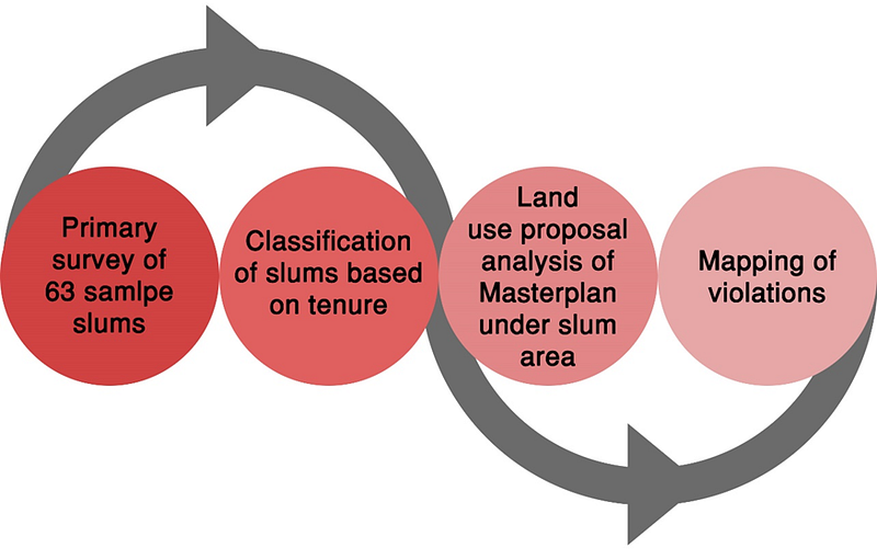
The report cross analyses the informal settlements with the proposals in the Master Plan for Ranchi projected for 2037. Primarily focused on the recognised slums, the report maps them, then develops a classification of typology based on their tenurial arrangements. After analysing the Master Plan provisions for the land under recognised slums, it maps the violations with regards to existing and proposed land use.
Understanding Ranchi’s Informal Settlements
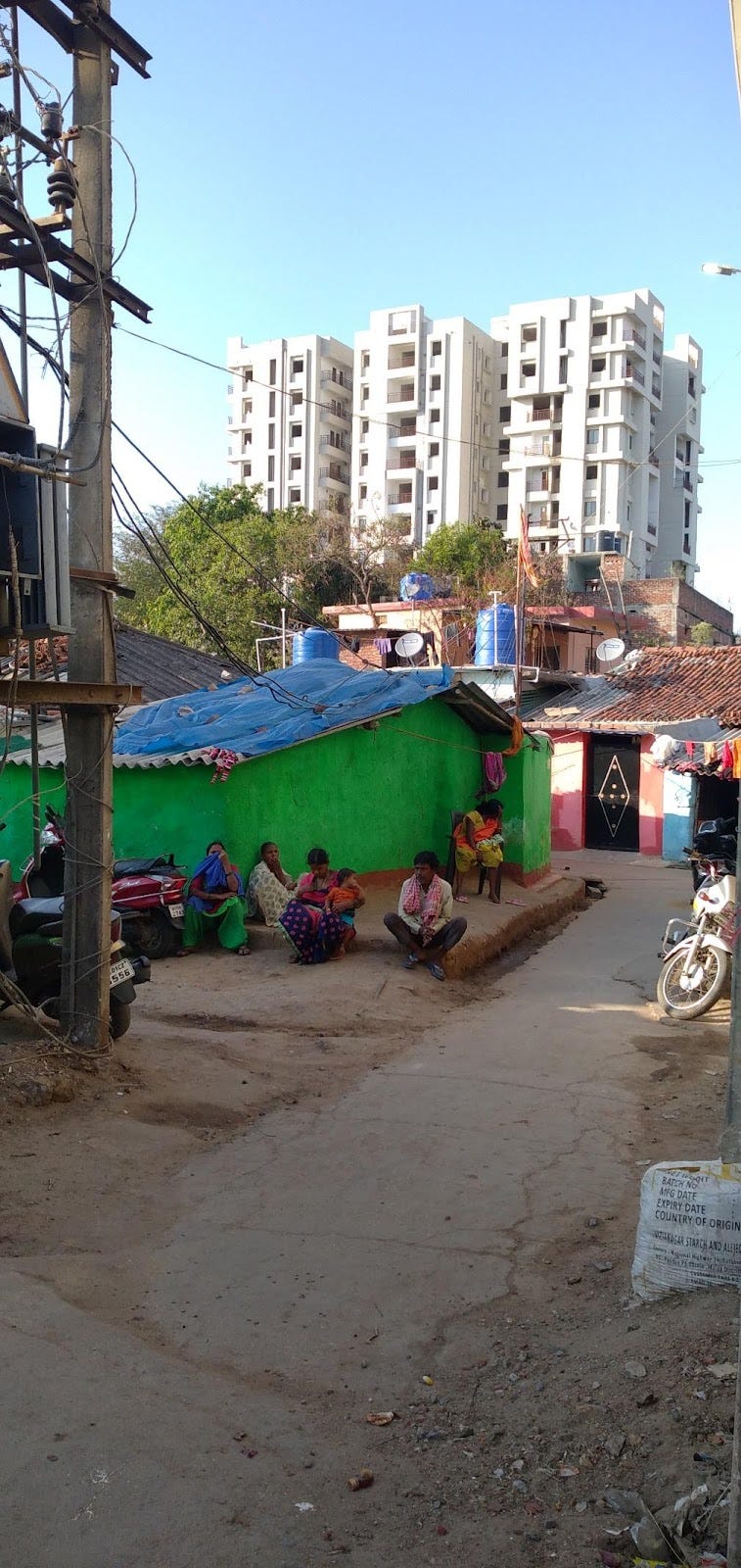
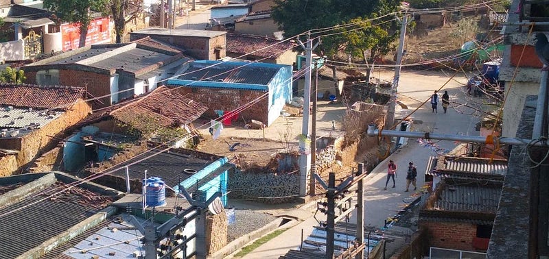
Presenting Ranchi as a dual city, in comparison to other ‘company towns’ of Jharkhand, the report makes some important observations regarding its informal housing fabric. In contrast to metro cities, the majority slums in the proposed Ranchi Planning Area present a different narrative. Of the 63 settlements sampled for the detailed study, only two are new (25 to 30 years old) in comparison to the rest which are 75–100 years old (Anand, 2017). A possible explanation of this is that most of the informal settlements of the city are actually pre-existing villages that have been engulfed by unregulated urbanisation.
Coupled with falling under the Fifth Schedule Area and applicability of the Chhota Nagpur Tenancy (CNT) Act which protects local tribal interests, the urban sprawl of Ranchi is riddled with a series of violations both by administration and people, which are responsible for the ills the city faces today (Kamaal, 2017; MOUD, 2013). The CNT Act restricts the sale of land from tribals to non-tribals but due to unsustainable incomes from agriculture, the native population is often found trapped in a cycle of poverty and debt which compels tribal farmers to sell land, through unlawful means (Sharan, Singh and Batra, 1999). The returns are also very low compared to the market price of non-tribal land (Brahmbhatt, 2019). Due to high illiteracy and non-familiarity with contemporary financial systems, most of the lands are gradually sold away with multiple legal issues still intact (Bhaskar, 2021). While under this umbrella of illegality, unregulated/unchecked residences keep developing, the Adivasi communities remain unable to benefit from urbanization and climb up the socio-economic ladder. Over time these village communities are regarded as slums by the municipal administration as soon as the Ranchi municipal boundary expands and subsumes these villages within its new formed boundaries. This pattern of non-inclusive, unauthorised and organic growth is bound to increase the population of its informal settlements as urbanisation spreads. As per Ranchi Municipal Corporation the city already has 254 recognised slums covering an area of 7.5 km2.
The proposed Master Plan for Ranchi for 2037 having ignored the provisions of the CNT Act and Panchayat Extension to Scheduled Areas Act does not propose any intervention for this deadlock of land restrictions and accessibility in detail (Anand, 2017). Even the national level Housing for all Action Plan, at state level in Jharkhand Affordable Housing Policy, 2016, has marked the importance of ‘People’, by incorporating the term into Public-Private partnership, which is known as ‘People-Public-Private-partnership’ (JAUHP, 2016) .
However, with no relevant mechanism active at the grassroots level and abrupt land use proposals in the Master Plan without any consultation with the native population, involuntarily the continuation of the same unauthorised-organic growth results in the loss of livelihood for tribal populations, converting their communities into slums. Constitutionally, until the ‘Municipal Extension to Schedule Areas Bill’ (which is similar to Panchayat Extension to Scheduled Areas Act) is passed, even expanding the boundary for the Ranchi Municipal Corporation will continue to face opposition which will continue the absence of social and physical infrastructure beyond municipal coverage (Bhaskar, 2021).
Key Report Highlights
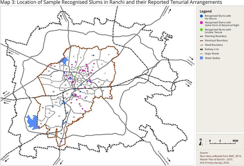
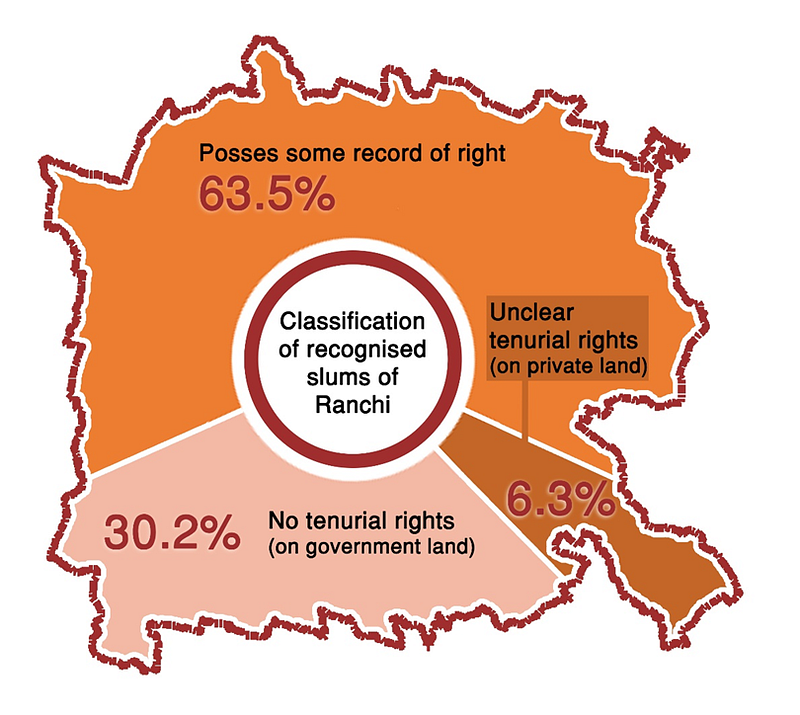
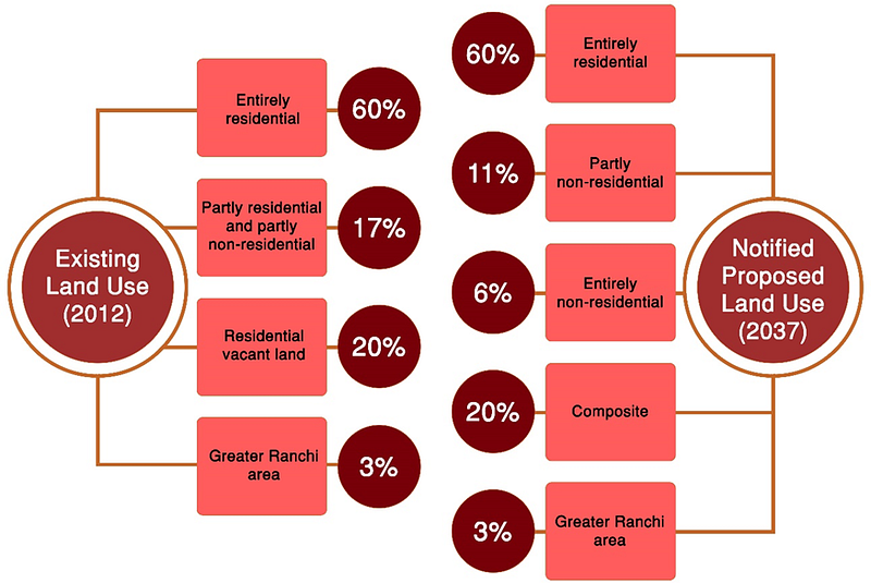
The primary survey of 63 sample slums (see map alongside) in the study substantiates the above situation through its results. Around 63.5 per cent of the sample settlements possessed some record of their rights over the land, whereas settlements identified on government land with no tenurial rights amounted to 30.2 per cent. The settlements with unclear tenurial rights which are on private lands are as low as 6.3 per cent of the sampled settlements. As shown in Figure 2, between the ‘Existing Land Use’ and ‘Notified Proposed Land Use’ , there has also been a change in these terminologies.
It is important to note that only about 4–5 informal settlements in the sample with no tenurial rights are present over non-residential land uses. As expressed in the diagram below, the proposed change in land use has resulted in shifting of a significant proportion of 20 per cent under composite use either fully or partially along with the residential use. It can be implied that the possibility of work in these ‘slums’ is enhanced; however, this could also lead to an increase in land value and the pressure it brings with itself. Also, previously secured under agricultural land uses, tribal village clusters have enjoyed autonomy, but such interventions from urban governance have put them under the threat of unwanted re-development or resettlement in the future, in turn, threatening their social stability.
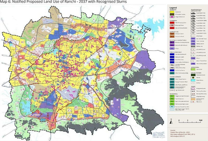
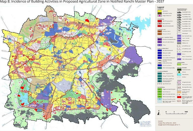
Since, there are numerous slums surrounding the Ranchi Municipal Corporation area, the report has attempted to map their built-up areas and analyse them by overlaying onto the Draft and Notified Proposed land use maps. This exercise hints towards hidden challenges along the conflict between Master Plan, land laws and unauthorised/unlawful urban expansion.
This complicated exclusiveness also demands a rethink of the nature of violations, by existing built-up and ongoing construction activities occurring with urbanisation outside the Ranchi Municipal Boundary. Though the notified Master Plan, by marking most of the agricultural land as residential, attempts to nullify these violations, the report also refers to the violations in terms of the CNT Act and other explorable contexts, which the Master Plan fails to counter. It is important to note such intricacies, especially for Ranchi, because there are a range of claims to property and land that have their own valid and legitimate histories because of the act. Hence, categorisation of these village clusters as slums would alter the kind of policy interventions that are possible in settlements that lack infrastructure and services but do possess strong claims of varying kinds to tenure.
Recommendations and Status
The report further suggests not to term villages entering urban limits as slums and necessitates identification of these settlements with varied histories and tenurial rights, as communities without basic services and infrastructure. Since residential land is being used for its intended purpose and is publicly owned as per the proposed Master Plan, upgradation and tenure expansion would not require a change of land use, authority for which can be granted under the municipal acts.
Some of the suggestions made by the report have already been considered in some manner by state and central agencies. For example, some of the evictions mentioned, like in Islam Nagar, have already been provided with ‘in-situ’ redevelopment partially under Basic Services to Urban Poor (BSUP) (Kislaya, 2014) and later Affordable Housing in Partnership (AHP) vertical of the Pradhan Mantri Awas Yojana (PMAY), (UDHD, 2017). Also, the Draft Zonal development plans were released for suggestions and objections in July, 2020, which are yet to be finalised and released officially.
To strengthen the engagement with the municipality and planning/development authorities, the study has argued for continuous assessment of the nature of violations and increase in the sample size for data collection and analysis, considering such data as a powerful tool which can used to argue about nuanced, contextual and particular solutions to address the tenurial and infrastructural needs of ‘slums’.